Yijun County
Appearance
You can help expand this article with text translated from the corresponding article in Chinese. (December 2008) Click [show] for important translation instructions.
|
Yijun County
宜君县 Ichun | |
|---|---|
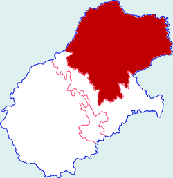
 Yijun in Tongchuan | |
 Tongchuan in Shaanxi | |
| Coordinates: 35°23′55″N 109°07′01″E / 35.3986°N 109.1169°E | |
| Country | People's Republic of China |
| Province | Shaanxi |
| Prefecture-level city | Tongchuan |
| Area | |
• Total | 1,531 km2 (591 sq mi) |
| Population (2012) | |
• Total | 92,100 |
| • Density | 60/km2 (160/sq mi) |
| Time zone | UTC+8 (China standard time) |
| Postal code | 727200 |
| Licence plates | 陕B |
Yijun County (Chinese: 宜君县; pinyin: Yíjūn Xiàn) is a county in the central part of Shaanxi province, China. It is the northernmost county-level division of the prefecture-level city of Tongchuan, and is located to the north of Guanzhong and at the southern edge of the Loess Plateau.
Administrative divisions
[edit]As 2020, Yijun County is divided to 1 subdistrict, 6 towns and 1 township.[1]
- Subdistricts
- Yiyang Subdistrict (宜阳街道)
- Towns
|
|
- Townships
- Yunmeng Township (云梦乡)
Climate
[edit]| Climate data for Yijun, elevation 1,395 m (4,577 ft), (1991–2020 normals, extremes 1981–2010) | |||||||||||||
|---|---|---|---|---|---|---|---|---|---|---|---|---|---|
| Month | Jan | Feb | Mar | Apr | May | Jun | Jul | Aug | Sep | Oct | Nov | Dec | Year |
| Record high °C (°F) | 16.4 (61.5) |
21.0 (69.8) |
26.0 (78.8) |
33.2 (91.8) |
32.0 (89.6) |
34.6 (94.3) |
32.8 (91.0) |
32.2 (90.0) |
32.8 (91.0) |
25.7 (78.3) |
22.6 (72.7) |
17.0 (62.6) |
34.6 (94.3) |
| Mean daily maximum °C (°F) | 1.1 (34.0) |
4.7 (40.5) |
10.5 (50.9) |
17.2 (63.0) |
21.3 (70.3) |
24.9 (76.8) |
25.8 (78.4) |
24.2 (75.6) |
19.7 (67.5) |
14.7 (58.5) |
8.9 (48.0) |
2.8 (37.0) |
14.7 (58.4) |
| Daily mean °C (°F) | −3.3 (26.1) |
0.0 (32.0) |
5.3 (41.5) |
11.7 (53.1) |
16.2 (61.2) |
20.1 (68.2) |
21.5 (70.7) |
20.0 (68.0) |
15.6 (60.1) |
10.3 (50.5) |
4.4 (39.9) |
−1.4 (29.5) |
10.0 (50.1) |
| Mean daily minimum °C (°F) | −6.4 (20.5) |
−3.4 (25.9) |
1.7 (35.1) |
7.6 (45.7) |
12.2 (54.0) |
16.2 (61.2) |
18.1 (64.6) |
16.8 (62.2) |
12.6 (54.7) |
7.2 (45.0) |
1.3 (34.3) |
−4.5 (23.9) |
6.6 (43.9) |
| Record low °C (°F) | −19.7 (−3.5) |
−15.7 (3.7) |
−12.1 (10.2) |
−6.1 (21.0) |
0.7 (33.3) |
6.9 (44.4) |
11.0 (51.8) |
8.5 (47.3) |
1.9 (35.4) |
−6.7 (19.9) |
−16.1 (3.0) |
−19.5 (−3.1) |
−19.7 (−3.5) |
| Average precipitation mm (inches) | 9.1 (0.36) |
12.3 (0.48) |
23.0 (0.91) |
41.0 (1.61) |
57.3 (2.26) |
86.8 (3.42) |
138.2 (5.44) |
123.8 (4.87) |
105.8 (4.17) |
55.9 (2.20) |
20.6 (0.81) |
5.1 (0.20) |
678.9 (26.73) |
| Average precipitation days (≥ 0.1 mm) | 4.3 | 4.8 | 6.2 | 7.4 | 9.3 | 10.0 | 13.1 | 12.5 | 11.7 | 9.8 | 5.7 | 3.6 | 98.4 |
| Average snowy days | 5.7 | 6.4 | 5.0 | 1.1 | 0 | 0 | 0 | 0 | 0 | 0.7 | 3.5 | 4.5 | 26.9 |
| Average relative humidity (%) | 49 | 51 | 50 | 49 | 54 | 60 | 73 | 77 | 74 | 65 | 54 | 48 | 59 |
| Mean monthly sunshine hours | 198.3 | 180.5 | 209.3 | 230.7 | 245.9 | 232.8 | 219.0 | 197.4 | 161.4 | 172.8 | 184.8 | 198.9 | 2,431.8 |
| Percent possible sunshine | 63 | 58 | 56 | 58 | 56 | 54 | 50 | 48 | 44 | 50 | 60 | 66 | 55 |
| Source: China Meteorological Administration[2][3] | |||||||||||||
Transportation
[edit]References
[edit]- ^ 2020年统计用区划代码(宜君县) (in Chinese). National Bureau of Statistics of China. 2020. Archived from the original on 2020-12-12. Retrieved 2020-12-11.
- ^ 中国气象数据网 – WeatherBk Data (in Simplified Chinese). China Meteorological Administration. Retrieved 26 August 2023.
- ^ 中国气象数据网 (in Simplified Chinese). China Meteorological Administration. Retrieved 26 August 2023.
