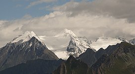
Hochfeiler
Appearance
| Hochfeiler | |
|---|---|
 | |
| Highest point | |
| Elevation | 3,510 m (11,520 ft) |
| Prominence | 981[1] |
| Listing | Alpine mountains above 3000 m |
| Coordinates | 46°58′22″N 11°43′34″E / 46.97278°N 11.72611°E |
| Geography | |
| Location | Tyrol, Austria / South Tyrol, Italy |
| Parent range | Zillertal Alps |
| Climbing | |
| First ascent | 24 July 1865 by Paul Grohmann, Georg Samer and Peter Fuchs |
The Hochfeiler (Italian: Gran Pilastro; German: Hochfeiler) is a mountain, 3,510 metres high, and the highest peak in the Zillertal Alps on the border between Tyrol, Austria, and South Tyrol, Italy.
The normal route to the summit
Hochfeiler (Gran Pilastro) is at the Austrian-Italian border. The Austrian side is completely under glacier. The normal south route from the Italian side is usually snow-free during the summer.
References
- ^ "Hochveiler - Peakbagger". Peakbagger.com. Retrieved 14 May 2020.
- Heinrich Klier, Walter Klier: Alpine Club Guide Zillertaler Alpen, Rother Verlag, Munich, (1996), ISBN 3-7633-1269-2
- Zeitschrift des Oesterreichischen Alpenvereins, Vol. II, page 127, Vienna, 1870/71
- Carl Diener in Eduard Richter (ed.): Die Erschließung der Ostalpen, Vol. III, Berlin, 1894
- Raimund von Klebelsberg: Geologie von Tirol, Berlin, 1935
- Alpine Club Map 1:25,000 series, Sheet 35/1
- Tabacco-Verlag, Udine, carta topografica 1:25,000, Sheet 037, Hochfeiler-Pfunderer Berge
External links
![]() Media related to Hochfeiler at Wikimedia Commons
Media related to Hochfeiler at Wikimedia Commons
- Hochfeiler - Gran Pilastro in Mountains for Everybody.
- Gran Pilastro - Hochfeiler in AllTrails


