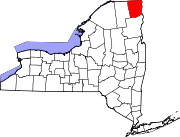
Schuyler Falls, New York
Schuyler Falls, New York | |
|---|---|
| Country | United States |
| State | New York |
| County | Clinton |
| Government | |
| • Type | Town Council |
| • Town Supervisor | Harold E. Ormsby (R) |
| • Town Council | Members' List |
| Area | |
• Total | 36.8 sq mi (95.4 km2) |
| • Land | 36.5 sq mi (94.6 km2) |
| • Water | 0.3 sq mi (0.8 km2) |
| Elevation | 561 ft (171 m) |
| Population (2010) | |
• Total | 5,181 |
| • Density | 142/sq mi (54.8/km2) |
| Time zone | UTC-5 (Eastern (EST)) |
| • Summer (DST) | UTC-4 (EDT) |
| ZIP code | 12985, 12962 |
| Area code | 518 |
| FIPS code | 36-65717 |
| GNIS feature ID | 0979474 |
| Website | www |
Schuyler Falls is a town in Clinton County, New York, United States. The population was 5,181 at the 2010 census.[1] The town was named after Peter Schuyler, who bought the mill on the Salmon River from Zephaniah Platt.
Schuyler Falls is in the south-central part of the county and is southwest of Plattsburgh.
History
The area was first settled around 1794 by Ezra Turner, who settled near the Salmon River, and built the first sawmill in 1801.
The town was formed from the town of Plattsburgh in 1848.
Geography
According to the United States Census Bureau, the town of Schuyler Falls has a total area of 36.8 square miles (95.4 km2), of which 36.5 square miles (94.6 km2) is land and 0.31 square miles (0.8 km2), or 0.82%, is water.[1]
The Saranac River forms the north town line, with the town of Plattsburgh on the opposite shore. The Salmon River runs through the southern part of the town, about 1 mile (1.6 km) north of the border with the town of Peru. Both rivers flow east into Lake Champlain.
New York State Route 22B is a north-south highway in the town, beginning east-west in the hamlet of Morrisonville.
Demographics
As of the census[2] of 2000, there were 5,128 people, 1,866 households, and 1,416 families residing in the town. The population density was 140.5 people per square mile (54.3/km²). There were 2,001 housing units at an average density of 54.8 per square mile (21.2/km²). The racial makeup of the town was 97.15% White, 1.09% African American, 0.31% Native American, 0.37% Asian, 0.23% from other races, and 0.84% from two or more races. Hispanic or Latino of any race were 0.84% of the population.
There were 1,866 households out of which 38.6% had children under the age of 18 living with them, 60.5% were married couples living together, 10.0% had a female householder with no husband present, and 24.1% were non-families. 16.8% of all households were made up of individuals and 5.5% had someone living alone who was 65 years of age or older. The average household size was 2.71 and the average family size was 3.03.
In the town the population was spread out with 28.2% under the age of 18, 7.5% from 18 to 24, 30.9% from 25 to 44, 24.6% from 45 to 64, and 8.8% who were 65 years of age or older. The median age was 36 years. For every 100 females there were 101.7 males. For every 100 females age 18 and over, there were 99.3 males.
The median income for a household in the town was $41,691, and the median income for a family was $45,262. Males had a median income of $33,242 versus $23,638 for females. The per capita income for the town was $18,294. About 7.4% of families and 9.6% of the population were below the poverty line, including 14.7% of those under age 18 and 1.0% of those age 65 or over.
Communities and locations in Schuyler Falls
- Banker Corners – A location at the southwest corner of the town.
- Fanlon Corners – A hamlet northwest of Schuyler Falls village.
- Macomb Reservation State Park – A state park in the south part of the town.
- Morrisonville – A hamlet by the north town line, partly in the Town of Plattsburgh.
- Norrisville – A former community located in the south part of the town.
- Rock Corners – A hamlet north of Schuyler Falls village.
- Salmon River – An important stream in the southern part of the town, flowing through the hamlet of Schuyler Falls.
- Schuyler Falls – The hamlet of Schuyler Falls on NY Route 22B. The community claims to have been founded in 1641 and incorporated as a village in 1758. It is no longer an incorporated village.
- Woods Mill – A hamlet in the northwest part of the town, west of Morrisonville by the Saranac River.
Media
- WOXR a classical music radio station. It is part of the Vermont Public Radio network and serves the Burlington, Vermont/Plattsburgh, New York area.
References
- ^ a b "Geographic Identifiers: 2010 Demographic Profile Data (G001): Schuyler Falls town, Clinton County, New York". U.S. Census Bureau, American Factfinder. Retrieved December 4, 2014.
- ^ "American FactFinder". United States Census Bureau. Retrieved 2008-01-31.

