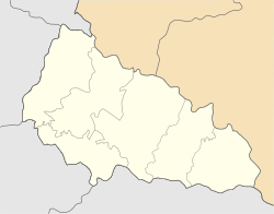
Halabor
Appearance
Halabor | |
|---|---|
Village | |
| Coordinates: 48°6′4″N 22°40′41″E / 48.10111°N 22.67806°E | |
| Country | |
| Oblast | Zakarpattia Oblast |
| Raion | Berehove Raion |
Halabor (Ukrainian: Галабор, Hungarian: Halábor) is a village in Zakarpattia Oblast (province) in western Ukraine.
Geography
[edit]The village is located 18 kilometres (11 mi) south of Berehove across the river from the Hungarian village of Szatmárcseke. The village is administered as part of the Berehove Raion, Zakarpattia Oblast.
History
[edit]The name originates from the word Hrábr. It was first mentioned as Harabur in 1300.
Population
[edit]In 1910, it had a population of 508, mostly Hungarians. Now the population is 640 inhabitants, of which 630 (98 per cent) are Hungarians.

