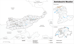
Moutier District
Appearance
Moutier District
District de Moutier | |
|---|---|
District | |
 | |
| Country | |
| Canton | |
| Capital | Moutier |
| Area | |
• Total | 216 km2 (83 sq mi) |
| Population (2007) | |
• Total | 22,954 |
| • Density | 110/km2 (280/sq mi) |
| Time zone | UTC+1 (CET) |
| • Summer (DST) | UTC+2 (CEST) |
| Municipalities | 26 |
Moutier District is one of the three French-speaking districts of the Bernese Jura in the canton of Bern with the seat being Moutier, the other two being Courtelary and La Neuveville. It had a population of about 23,098 in 2004.
From 1 January 2010, the district lost its administrative power while being replaced by the Bernese Jura, whose administrative centre is Courtelary.[1] Since 2010, it remains therefore a fully recognised district under the law and the Constitution (Art.3 al.2) of the Canton of Berne.
| Municipality | Population (Dec 2007)[2] | Area (km²) |
|---|---|---|
| Belprahon | 316 | 3.79 |
| Bévilard | 1700 | 5.63 |
| Champoz | 153 | 7.11 |
| Châtelat | 123 | 4.09 |
| Corcelles BE | 237 | 6.78 |
| Court BE | 1381 | 24.60 |
| Crémines | 551 | 9.35 |
| Elay (Seehof) | 82 | 8.42 |
| Eschert | 363 | 6.56 |
| Grandval | 340 | 8.21 |
| Loveresse | 324 | 4.64 |
| Malleray | 1914 | 10.35 |
| Monible | 37 | 3.39 |
| Moutier | 7462 | 19.53 |
| Perrefitte | 489 | 8.67 |
| Pontenet | 198 | 2.74 |
| Rebévelier | 51 | 3.52 |
| Reconvilier | 2227 | 8.23 |
| Roches | 227 | 8.97 |
| Saicourt | 577 | 13.75 |
| Saules BE | 155 | 4.25 |
| Schelten (La Scheulte) | 49 | 5.61 |
| Seehof | 72 | 8.4 |
| Sornetan | 130 | 5.62 |
| Sorvilier | 271 | 7.02 |
| Souboz | 129 | 10.63 |
| Tavannes | 3478 | 14.65 |
References
[edit]- ^ Nomenklaturen – Amtliches Gemeindeverzeichnis der Schweiz (in German) accessed 4 April 2011
- ^ Swiss Federal Statistical Office Archived 2011-09-04 at the Wayback Machine accessed 07-Jul-2009
