Subprefecture of Santo Amaro
This article relies largely or entirely on a single source. (February 2018) |
This article needs additional citations for verification. (February 2018) |
Subprefecture of Santo Amaro | |
|---|---|
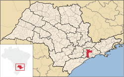
 Location of the Subprefecture of Santo Amaro in São Paulo | |
 Location of municipality of São Paulo within the State of São Paulo | |
| Country | |
| Region | Southeast |
| State | |
| Municipality | |
| Administrative Zone | South-Central |
| Districts | Santo Amaro, Campo Belo, Campo Grande |
| Government | |
| • Type | Subprefecture |
| • Subprefect | Ailton Araujo Brandão |
| Area | |
• Total | 37.8 km2 (14.6 sq mi) |
| Population (2005) | |
• Total | 207,421 |
| Website | Subprefeitura Santo Amaro (Portuguese) |
The Subprefecture of Santo Amaro is one of 32 subprefectures of the city of São Paulo, Brazil. It comprises three districts: Santo Amaro, Campo Belo, and Campo Grande.[1]
Once part of an independent municipality, this subprefecture hosts the Congonhas Airport, the Apple Store of São Paulo and the Brazilian headquarters of many companies such as Deloitte, SAP, Oracle, KPMG, Cargill, Electrolux and PepsiCo, as well as the Brazilian companies Banco Votorantim, NET and Vivo. This subprefecture also features many theatres and concert halls and has the famous cable-stayed Octávio Frias de Oliveira Bridge, one of the landmarks of São Paulo, connecting it to the subprefecture of Butantã, in the other side of the river.
See also
[edit]References
[edit]- ^ Official Subprefecture Website (Portuguese) Archived 2011-01-27 at the Wayback Machine
External links
[edit]23°39′S 46°42′W / 23.650°S 46.700°W
