Walton Township, Harvey County, Kansas
Appearance
Walton Township | |
|---|---|
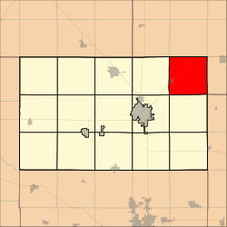
 Location in Harvey County | |
| Coordinates: 38°07′51″N 97°12′32″W / 38.1307472°N 97.2088825°W[1] | |
| Country | United States |
| State | Kansas |
| County | Harvey |
| Area | |
• Total | 36.69 sq mi (95.02 km2) |
| • Land | 36.66 sq mi (94.96 km2) |
| • Water | 0.02 sq mi (0.06 km2) 0.06% |
| Elevation | 1,467 ft (447 m) |
| Population (2000) | |
• Total | 552 |
| • Density | 15.1/sq mi (5.8/km2) |
| Time zone | UTC-6 (CST) |
| • Summer (DST) | UTC-5 (CDT) |
| Area code | 620 |
| FIPS code | 20-75225 [1] |
| GNIS ID | 477771 [1] |
| Website | County website |
Walton Township is a township in Harvey County, Kansas, United States.[1] As of the 2000 census, its population was 552.
Geography
Walton Township covers an area of 36.69 square miles (95.0 km2) and contains one incorporated settlement, Walton.
Cemeteries
According to the USGS, it contains one cemetery, Walton.
References
Further reading
External links
- Harvey County Website
- City-Data.com
- Harvey County maps: Current, Historic, KDOT

