De Stafford School: Difference between revisions
No edit summary Tags: Mobile edit Mobile web edit |
m Reverted edits by 86.133.148.238 (talk) to last version by DavidBrooks |
||
| Line 3: | Line 3: | ||
{{Use British English|date=July 2019}} |
{{Use British English|date=July 2019}} |
||
{{Infobox school |
{{Infobox school |
||
| name = de |
| name = de Stafford School |
||
| image = |
| image = |
||
| image_size = |
| image_size = |
||
| Line 13: | Line 13: | ||
| president = |
| president = |
||
| head_label = Headteacher |
| head_label = Headteacher |
||
| head = Mr |
| head = Mr Jeremy Garner |
||
| r_head_label = |
| r_head_label = |
||
| r_head = |
| r_head = |
||
Revision as of 23:26, 16 November 2019
| de Stafford School | |
|---|---|
| Address | |
 | |
Burntwood Lane , , CR3 5YX | |
| Coordinates | 51°17′35″N 0°05′05″W / 51.29319°N 0.08463°W |
| Information | |
| Type | Academy school |
| Motto | Grow, Learn, Believe and Achieve |
| Local authority | Surrey County Council |
| Department for Education URN | 125308 Tables |
| Ofsted | Reports |
| Headteacher | Mr Jeremy Garner |
| Gender | Mixed |
| Age | 11 to 16 |
| Enrolment | 770 |
| Colour(s) | Black and red |
| Website | http://www.destafford.org.uk/ |
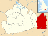
de Stafford School is a mixed secondary school located in Caterham, Surrey, England. The school educates students from ages 11 to 16.
Organisation
de Stafford is a comprehensive school with a foundation school status, and is recognised as an information and communications technology and mathematics centre of excellence. It is close to the centre of the scattered town of Caterham, bordering on two sides the south-western part of the London Borough of Croydon.[1]
The school employs more than 100 academic and facilities/administration support staff. It currently has an average intake of 180 students per year. Acting as a preliminary school to more advanced, applied or theoretical studies at further education colleges, the nearest such state-supported institutions are in Purley, Croydon and Redhill. The school helps students in their final year to apprentice at a skilled trade or profession.[2]
The school has access to a large sports centre (shared with Tandridge Trust), complete with a 25m swimming pool and an air-conditioned sports hall.
History
A parish school was opened in 1804. After enlargements this was superseded by Caterham County Council school that was built in 1872 and enlarged in 1893 and 1909. The school has its origins in this institution and derives its name from a wealthy and politically influential Middle Ages noble who owned one of the manors of the former village in 1372, Ralph de Stafford, 1st Earl of Stafford, whose wealthy wife Margaret de Audley, 2nd Baroness Audley owned as co-heir a large set of estates before their marriage, including this land.[3]
Students
The make-up of students varies according to a wide set of catchment areas drawing on parts of the London Borough of Croydon, Tandridge District and a small part of the Borough of Reigate and Banstead. In 2011 the proportion of students with learning difficulties and/or disabilities was below average, however it was above average when compared with students with a Statement of Special Educational Needs. In 2013 6.4% of children at the school did not list English as their primary language.[2]
In statistics
| OFSTED periodic inspection grade (1 = excellent 4 = inadequate)[4] | |
|---|---|
| Year | Rating |
| 2015 | 2 |
| 2011 | 2 |
| 2007 | 3 |
| 2003 | 3 |
Due to a franchised sixth form in Purley included in the roll in 2003, the number of students at the time of that inspection was 990.
| Percentage of students achieving 5+ A*-C GCSEs (or equivalent) including English and maths |
2009 | 2010 | 2011 | 2012 |
|---|---|---|---|---|
| School | 43% | 53% | 50% | 54% |
| Local Authority | 58.8% | 62% | 63.5% | 64.2% |
| England | 49.8% | 53.5% | 59% | 59.4% |
Head teachers
| Headteacher | Years in office |
|---|---|
| John Gribbon | |
| Gerry Wadwa | |
| Mark Phillips | September 2004 – April 2010 |
| Caroline Longhurst | April 2010 – February 2013 |
| Keith Sharp | February 2013 – July 2013 |
| Jeremy Garner | September 2013 – current |
Transport
The school is connected by bus to the most significant residential estates of the settlements surrounding Caterham and to the largest mixed use urban areas, such as Croydon, Coulsdon and Purley town centres. The school also connects to the north and north-west via Caterham railway station.[5]
References
- ^ OS Map Archived April 24, 2012, at the Wayback Machine
- ^ a b Data, research and statistics - Performance Tables - School details last updated 19 Sep 2013 Department for Education
- ^ H.E. Malden (editor) (1912). "Parishes: Caterham". A History of the County of Surrey: Volume 4. Institute of Historical Research. Retrieved 27 October 2013.
{{cite web}}:|author=has generic name (help) - ^ Ofsted Inspection Reports: de Stafford School Retrieved 27 October 2013
- ^ Public transport and school services in Surrey Surrey County Council Retrieved 27 October 2013

