Circuito Norte: Difference between revisions
Appearance
Content deleted Content added
m m |
m fix |
||
| Line 25: | Line 25: | ||
===Table=== |
===Table=== |
||
The table below shows the route of the |
The table below shows the route of the Circuito Norte.<ref name=MapaCu/> Note: Provincial seats are shown in bold; the names shown under brackets in the section "Municipality" indicate the municipal seats. |
||
{| class="wikitable sortable" |
{| class="wikitable sortable" |
||
!width="180px"| Settlement |
!width="180px"| Settlement |
||
Revision as of 14:23, 29 June 2018
This article or section is in a state of significant expansion or restructuring. You are welcome to assist in its construction by editing it as well. If this article or section has not been edited in several days, please remove this template. If you are the editor who added this template and you are actively editing, please be sure to replace this template with {{in use}} during the active editing session. Click on the link for template parameters to use.
This article was last edited by DerBorg (talk | contribs) 6 years ago. (Update timer) |
| Circuito Norte (CN) | |
|---|---|
| Northern Circuit | |
 | |
| Route information | |
| Length | 1,222 km (759 mi) |
| Major junctions | |
| West end | Mantua (Pinar del Río Province) |
| East end | Baracoa (Guantánamo Province) |
| Location | |
| Country | Cuba |
| Major cities | Mantua, Mariel, Havana, Santa Cruz del Norte, Matanzas, Varadero, Cárdenas, Sagua la Grande, Remedios, Caibarién, Yaguajay, Morón, Nuevitas, Puerto Padre, Holguín, Mayarí, Sagua de Tánamo, Moa, Baracoa |
| Highway system | |
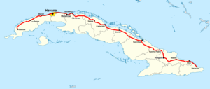
The Circuito Norte (CN), meaning "Northern Circuit", is a west-east highway spanning the length of the island of Cuba, through the Atlantic Coast.[1] It is the second-longest Cuban highway after the "Carretera Central", which crosses the island through the middle of it.
Route
Description
Table
The table below shows the route of the Circuito Norte.[1] Note: Provincial seats are shown in bold; the names shown under brackets in the section "Municipality" indicate the municipal seats.
| Settlement | Municipality | Province |
|---|---|---|
| Mantua | (Mantua) | Pinar del Río |
| Vista Hermosa | Mantua | Pinar del Río |
| Dimas (crossroad) | Mantua | Pinar del Río |
See also
References
- ^ a b Source: Mapa de Carreteras de Cuba (Road map of Cuba). Ediciones GEO, Havana 2011 - ISBN 959-7049-21-X
External links
![]() Media related to Circuito Norte at Wikimedia Commons
Media related to Circuito Norte at Wikimedia Commons
