Masonville, Colorado: Difference between revisions
Appearance
Content deleted Content added
JJMC89 bot (talk | contribs) Migrate {{Infobox settlement}} coordinates parameters to {{Coord}}, see Wikipedia:Coordinates in infoboxes |
|||
| Line 104: | Line 104: | ||
|timezone_DST = [[Mountain Time Zone|MDT]] |
|timezone_DST = [[Mountain Time Zone|MDT]] |
||
|utc_offset_DST = -6 |
|utc_offset_DST = -6 |
||
| |
|coordinates = {{coord|40|29|14|N|105|12|36|W|region:US_type:city|display=inline,title}} |
||
|coordinates_type = region:US_type:city |
|||
|latd= 40 |
|||
|latm= 29 |
|||
|lats= 14 |
|||
|latNS=N |
|||
|longd= 105 |
|||
|longm= 12 |
|||
|longs= 36 |
|||
|longEW=W |
|||
|elevation_footnotes = <ref name="GR3" /> |
|elevation_footnotes = <ref name="GR3" /> |
||
|elevation_m = 1642 |
|elevation_m = 1642 |
||
Revision as of 14:40, 25 March 2017
Masonville, Colorado | |
|---|---|
 General store in Masonville, Colorado. | |
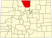
Location in Larimer County and the state of Colorado | |
| Coordinates: 40°29′14″N 105°12′36″W / 40.48722°N 105.21000°W | |
| Country | |
| State | |
| County | Larimer[1] |
| Elevation | 5,387 ft (1,642 m) |
| Time zone | UTC-7 (MST) |
| • Summer (DST) | UTC-6 (MDT) |
| ZIP code[2] | 80541 |
| Area code | 970 |
| GNIS feature ID | 0204676 |
Masonville is an unincorporated community and a U.S. Post Office in Larimer County, Colorado, United States. The Masonville Post Office has the ZIP Code 80541.[2]
Geography
Masonville is located at 40°29′14″N 105°12′36″W / 40.48722°N 105.21000°W (40.487171,-105.210056).
References
- ^ a b "US Board on Geographic Names". United States Geological Survey. 2007-10-25. Retrieved 2008-01-31.
- ^ a b "ZIP Code Lookup" (JavaScript/HTML). United States Postal Service. January 2, 2007. Retrieved January 2, 2007.


