Margalef: Difference between revisions
Appearance
Content deleted Content added
m →External links: {{Official site}} |
m →External links: rm unnecessary {{br}} |
||
| Line 85: | Line 85: | ||
* http://www.rockfax.com/databases/results_crag.html?id=122 |
* http://www.rockfax.com/databases/results_crag.html?id=122 |
||
{{br}} |
|||
{{Geographic location |
{{Geographic location |
||
|Centre = Margalef |
|Centre = Margalef |
||
Revision as of 04:57, 1 March 2016
Margalef | |
|---|---|
 | |
| Country | |
| Autonomous community | |
| Province | Tarragona |
| Comarca | Priorat |
| Government | |
| • mayor | Joaquim Vila Gibert (2015)[1] |
| Area | |
• Total | 34.7 km2 (13.4 sq mi) |
| Elevation | 379 m (1,243 ft) |
| Population (2014)[1] | |
• Total | 108 |
| • Density | 3.1/km2 (8.1/sq mi) |
| Demonym(s) | Margalefà, margalefana |
| Website | margalef |


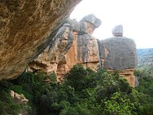
Margalef is a village in Catalonia, Spain. It is situated on the edge of Montsant and is a popular ecotourism destination, especially among rock climbers. The rock type is conglomerate and it has more than 500 climbing routes of different grades, from 4 to 9b. Many of the buildings in the village are also built on conglomerate formations.
Margalef's important economic activity is agriculture, mainly producing olives, almonds, and fruits.
References
- ^ a b "Ajuntament de Margalef". Generalitat of Catalonia. Retrieved 2015-11-13.
- ^ "El municipi en xifres: Margalef". Statistical Institute of Catalonia. Retrieved 2015-11-23.

