Bergen Point: Difference between revisions
Pin down development location and label ref |
→External links: stub sorting, plus any auto genfixes, removed stub tag using AWB |
||
| Line 84: | Line 84: | ||
{{ |
{{HudsonCountyNJ-geo-stub}} |
||
Revision as of 07:10, 12 November 2015
Bergen Point | |
|---|---|
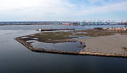
 Southwestern tip of Bergen Point | |
| Country | United States |
| State | New Jersey |
| County | Hudson |
| City | Bayonne |
| Elevation | 7 ft (2 m) |
| Area code | 201 |
| GNIS feature ID | 874681[1] |
Bergen Point is a point of land that lends its name to the adjacent neighborhood in Bayonne in Hudson County, New Jersey, United States.[2] The point is located on the north side of Kill van Kull at Newark Bay. It is the section of the city closest to the Bayonne Bridge.[3] Historically the term has been used more broadly as synonymous with Constable Hook, from which it is geographically separated at Port Johnson.
The area was connected to Staten Island with a ferry as early as the late 17th century, and was later developed as a resort.[4] In the late 18th century it become more prominent as a ferry landing for travellers between New York and Philadelphia.[5] The Bergen Point Lighthouse, built offshore in 1849, was demolished and replaced with a skeletal tower in the mid 20th century.[6] A charter was granted for the construction of The Jersey City and Bergen Point Plank Road in 1851.[7]
Governor of New Jersey Jon Corzine announced on May 6, 2006, that funding was in place to extend the Hudson-Bergen Light Rail system to Eighth Street. Work was completed and the station opened in January 2011.[8]
A large portion of the point was once site of a Texaco plant, which was cleared and is slated to become a residential and recreational area along Newark Bay and Kill Van Kull.[9]
Gallery
-
The Latourette House in Bergen Point was the birthplace of Samuel Francis Du Pont[10]
-
Bergen Point, 1974
-
The point lends its name to the neighborhood
See also
- Bergen Neck
- Hackensack RiverWalk
- Geography of New York–New Jersey Harbor Estuary
- Port of New York and New Jersey
References
- ^ a b "Bergen Point". Geographic Names Information System. United States Geological Survey, United States Department of the Interior.
- ^ Locality Search, State of New Jersey. Accessed February 7, 2015.
- ^ Hudson County New Jersey Street Map. Hagstrom Map Company, Inc. 2008. ISBN 0-88097-763-9.
- ^ Bergen Point
- ^ Paulus Hook Ferry
- ^ Bergen Point Lighthouse, 1849-1949, New Jersey Lighthouse Society.
- ^ Laws of the State of New Jersey, 1811, pp. 337-340
- ^ Frassinelli, Mike. "NJ Transit opens Bayonne 8th Street Station, extending Hudson-Bergen Light Rail service", The Star-Ledger, January 31, 2011. Accessed August 25, 2013.
- ^ 1,200 housing units, recreation facilities planned for former Texaco site in Bayonne Jersey Journal, Sept 2015
- ^ "Part of What the World Did not Know Until Now" (PDF). Bayonne Public Library. November 19, 1946.
External links
- Bergen Point West Reach data station ID 8519483 Physical Oceanographic Real-Time System, NOAA.
- Bayonne Constable Hook Cemetery.

![The Latourette House in Bergen Point was the birthplace of Samuel Francis Du Pont[10]](http://upload.wikimedia.org/wikipedia/commons/thumb/0/00/The_Latourette_House%2C_Bergen_Point%2C_New_Jersey.jpg/120px-The_Latourette_House%2C_Bergen_Point%2C_New_Jersey.jpg)


