Zuénoula Department: Difference between revisions
No edit summary |
|||
| Line 71: | Line 71: | ||
In 2011, [[Districts of Ivory Coast|districts]] were introduced as new first-level subdivisions of Ivory Coast. At the same time, regions were reorganised and became second-level subdivisions and all departments were converted into third-level subdivisions. At this time, Zuénoula Department remained part of the retained [[Marahoué Region]] in the new [[Sassandra-Marahoué District]]. |
In 2011, [[Districts of Ivory Coast|districts]] were introduced as new first-level subdivisions of Ivory Coast. At the same time, regions were reorganised and became second-level subdivisions and all departments were converted into third-level subdivisions. At this time, Zuénoula Department remained part of the retained [[Marahoué Region]] in the new [[Sassandra-Marahoué District]]. |
||
In 2020, it was divided to create the [[Gohitafla Department]]. |
In 2020, it was divided to create the [[Gohitafla Department]].<ref>[https://lexterra.ci/data/domaine/coll_terr/CT2/2020-09-30%20D2020-767%20Cr%c3%a9ation%20D%c3%a9p%20BONON%20&%20GOHITAFLA.pdf “Décret n°2020-267 du 30 Setembre 2020 portant création de circonscriptions administratives”].</ref> |
||
==Notes== |
==Notes== |
||
{{Reflist}} |
{{Reflist}} |
||
Revision as of 11:00, 9 November 2023
Zuénoula Department
Département de Zuénoula | |
|---|---|
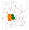
 Location in Ivory Coast. Zuénoula Department has these boundaries since 2020. | |
| Country | |
| District | Sassandra-Marahoué |
| Region | Marahoué |
| 1980 | Established as a first-level subdivision via a division of Bouaflé Dept |
| 1997 | Converted to a second-level subdivision |
| 2011 | Converted to a third-level subdivision |
| 2020 | Divided to create the Gohitafla Dept |
| Departmental seat | Zuénoula |
| Government | |
| • Prefect | Basile Niamkey |
| Area | |
• Total | 2,196 km2 (848 sq mi) |
| Population (2021 census)[3] | |
• Total | 184,882 |
| • Density | 84/km2 (220/sq mi) |
| Time zone | UTC+0 (GMT) |
Zuénoula Department is a department of Marahoué Region in Sassandra-Marahoué District, Ivory Coast. In 2021, its population was 184,882 and its seat is the settlement of Zuénoula. The sub-prefectures of the department are Iriéfla, Kanzra, Vouéboufla, and Zanzra.
History
Zuénoula Department was created in 1980 as first-level subdivision via a split-off from Bouaflé Department.[4] In 1997, regions were introduced as new first-level subdivisions of Ivory Coast; as a result, all departments were converted into second-level subdivisions. Zuénoula Department was included in Marahoué Region.
In 2011, districts were introduced as new first-level subdivisions of Ivory Coast. At the same time, regions were reorganised and became second-level subdivisions and all departments were converted into third-level subdivisions. At this time, Zuénoula Department remained part of the retained Marahoué Region in the new Sassandra-Marahoué District.
In 2020, it was divided to create the Gohitafla Department.[5]
Notes
- ^ "Préfets de Région et de Préfets de Département (Conseil des ministres du mercredi 26 septembre 2012)", abidjan.net, 2 October 2012.
- ^ "Découverte de la Marahoué", ardci-rd.org, accessed 23 February 2016.
- ^ Citypopulation.de Population of the regions and departments of Ivory Coast
- ^ "Regions of Côte d'Ivoire (Ivory Coast)", statoids.com, accessed 16 February 2016.
- ^ “Décret n°2020-267 du 30 Setembre 2020 portant création de circonscriptions administratives”.
7°26′N 6°3′W / 7.433°N 6.050°W


