Agena Castle: Difference between revisions
No edit summary |
Brianjester (talk | contribs) m Add official website |
||
| Line 15: | Line 15: | ||
|demolished= |
|demolished= |
||
|condition=Ruins |
|condition=Ruins |
||
|website= {{URL|https://www.city.uruma.lg.jp/bunka/2399}} |
|||
|ownership= |
|ownership= |
||
|controlledby=Ōgawa Aji (14th century-15th century)<br/>{{flag|Ryūkyū Kingdom|size=22px}} (15th century–1879)<br/>{{flag|Empire of Japan|size=22px}} (1879–1945)<br/>[[File:US flag 48 stars.svg|border|25x20px]] [[United States Military Government of the Ryukyu Islands]] (1945–1950)<br/>[[File:US flag 48 stars.svg|border|25x20px]] [[United States Civil Administration of the Ryukyu Islands]](1950–1972)<br/>{{flag|Japan|size=22px}} (1972–present) |
|controlledby=Ōgawa Aji (14th century-15th century)<br/>{{flag|Ryūkyū Kingdom|size=22px}} (15th century–1879)<br/>{{flag|Empire of Japan|size=22px}} (1879–1945)<br/>[[File:US flag 48 stars.svg|border|25x20px]] [[United States Military Government of the Ryukyu Islands]] (1945–1950)<br/>[[File:US flag 48 stars.svg|border|25x20px]] [[United States Civil Administration of the Ryukyu Islands]](1950–1972)<br/>{{flag|Japan|size=22px}} (1972–present) |
||
Revision as of 04:26, 12 February 2023
26°22′51″N 127°50′54″E / 26.380885°N 127.8481976°E
| Agena Castle 安慶名城 | |
|---|---|
| Uruma, Okinawa | |
 | |
| Type | Gusuku |
| Site information | |
| Controlled by | Ōgawa Aji (14th century-15th century) |
| Open to the public | yes |
| Condition | Ruins |
| Website | www |
| Site history | |
| Built | early 14th century |
| Built by | Ōgawa Aji |
| In use | early 14th century-15th century |
| Materials | Ryukyuan limestone, wood |
| Garrison information | |
| Occupants | Ōgawa Aji, Aji of Gushikawa Magiri |
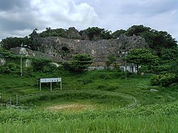
Agena Castle (安慶名城, Agena jō, Okinawan: Agina Gushiku[1] or Aginaa Gushiku[2]) is a Ryukyuan gusuku located in the north of Agena district of Uruma, Okinawa, in former Gushikawa City. It was built on a base of Ryukyuan limestone and occupies 8,000 square metres (86,000 sq ft). Agena Castle sits at an altitude of 49 metres (161 ft), and is naturally protected by the Tengan River to the north.[3]
History
The Ōgawa Aji, or regional ruler of the Ōgawa Magiri of the Ryukyu Kingdom, occupied the castle for several generations. For this reason the castle is also known as Ōgawa Castle (大川城, Ōgawa jō). Details of the history of both the castle and the Aji are unclear, and no archaeological excavation has been carried out on the castle. It was likely built in the 14th century.[3] The Ōgawa reached their greatest period of prosperity in the 15th century.[4] At some point the castle was destroyed by the Ryukyuan army. The outer gate of Agena Castle no longer exists, but as the inner gate is bored through the limestone foundation and is surround on both sides with quarried rocks, it still exists. The inner gate is an early example of an arched castle gate, and is protected as a national treasure of Japan. The castle remains now holds numerous utaki sites of worship of the Ryukyuan religion, and is scattered with fragments of Chinese ceramics from the 14th to the 15th century.[4] The area around the castle is now used as Agena Park.[3][4]
References
- ^ "アギナ". 首里・那覇方言音声データベース (in Japanese).
- ^ "アギナー". 首里・那覇方言音声データベース (in Japanese).
- ^ a b c "安慶名城" [Agena Castle]. Nihon Rekishi Chimei Taikei (in Japanese). Tokyo: Shogakukan. 2013. OCLC 173191044. Retrieved 2014-05-23.
- ^ a b c "安慶名城" [Agena Castle]. Nihon Daihyakka Zensho (Nipponika) (in Japanese). Tokyo: Shogakukan. 2012. OCLC 153301537. Retrieved 2014-05-23.
