Back of the Hill station: Difference between revisions
Update infobox parameters |
Add administrative subdivision parameter |
||
| Line 1: | Line 1: | ||
{{Short description|Light rail station in Boston, Massachusetts}} |
{{Short description|Light rail station in Boston, Massachusetts}} |
||
{{Infobox station |
{{Infobox station |
||
| name = Back of the Hill |
|||
| style = MBTA |
|||
| style2 = Green |
|||
| image = Back of the Hill MBTA station, Boston MA.jpg |
|||
| image_caption = An inbound train at Back of the Hill station in 2011 |
|||
| address = South Huntington Avenue at Back of the Hill |
|||
| borough = [[Boston]], Massachusetts |
|||
| coordinates = {{Coord|42|19|45.79|N|71|6|39.46|W|display=title, inline}} |
|||
| line = |
|||
| connections = {{bus icon}} [[MBTA bus]]: {{MBTABus|39}}, {{MBTABus|192}} |
|||
| platform = None (passengers wait on sidewalk) |
|||
| tracks = 2 |
|||
| bicycle = |
|||
| passengers = 35 (weekday average)<ref name=bluebook>{{MBTA Bluebook 2014}}</ref> |
|||
| pass_year = 2011 |
|||
| opened = {{circa|1982}} |
|||
| rebuilt = |
|||
| disabled = No |
|||
| services = {{Adjacent stations|system=MBTA|line=Green|type=E|left=Heath Street|right=Riverway}} |
|||
}} |
}} |
||
Revision as of 18:36, 3 May 2022
Back of the Hill | |||||||||||
|---|---|---|---|---|---|---|---|---|---|---|---|
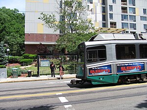
 An inbound train at Back of the Hill station in 2011 | |||||||||||
| General information | |||||||||||
| Location | South Huntington Avenue at Back of the Hill Boston, Massachusetts | ||||||||||
| Coordinates | 42°19′45.79″N 71°6′39.46″W / 42.3293861°N 71.1109611°W | ||||||||||
| Platforms | None (passengers wait on sidewalk) | ||||||||||
| Tracks | 2 | ||||||||||
| Connections | |||||||||||
| Construction | |||||||||||
| Accessible | No | ||||||||||
| History | |||||||||||
| Opened | c. 1982 | ||||||||||
| Passengers | |||||||||||
| 2011 | 35 (weekday average)[1] | ||||||||||
| Services | |||||||||||
| |||||||||||
Back of the Hill station is a surface stop on the light rail MBTA Green Line E branch, located in the Mission Hill neighborhood of Boston, Massachusetts. It is named after, and primarily serves, the adjacent Back of the Hill apartment complex, a Section 8 development for elderly and disabled residents. Back of the Hill is located on the street running section of the E branch on South Huntington Avenue. The station has no platforms; passengers wait in bus shelters (shared with route 39 buses) on the sidewalks and cross a traffic lane to reach Green Line trains.[2]
History

The Boston Elevated Railway opened streetcar tracks on the newly-laid-out South Huntington Avenue between Centre Street and Huntington Avenue on May 11, 1903. The company began Jamaica Plain–Park Street service via South, Centre, South Huntington, and Huntington as a branch of existing Boston–Brookline service on Huntington Avenue.[3][4]: 61 All Huntington Avenue service (except for Northeastern University and Brigham Circle short turns) operated on South Huntington after September 10, 1938.[5] The line became part of the Metropolitan Transit Authority in 1947, and part of the Massachusetts Bay Transportation Authority (MBTA) in 1967; it was designated as the E Branch of the MBTA Green Line in 1967.[6]
By the 1970s, E Branch trains stopped at Riverway and Heath Street, with no stop between them.[7] The Back of the Hill apartment complex, located just north of Heath Street, was built in 1980 and opened in 1981.[8][9][10] The E Branch was closed for track work from June 21, 1980, to June 26, 1982; trains began stopping at Back of the Hill then or after.[6]
Back of the Hill is the least-used stop on the MBTA subway system, averaging only 35 riders per day by a 2011 count. It was one of only four stops to average fewer than 100 riders per day.[1][note 1] In 2021, the MBTA indicated plans to modify the Heath Street–Brigham Circle section of the E branch with accessible platforms to replace the existing non-accessible stopping locations.[11]
References
- ^ a b "Ridership and Service Statistics" (PDF) (14th ed.). Massachusetts Bay Transportation Authority. 2014.
- ^ "Back of the Hill Station Neighborhood Map" (PDF). Massachusetts Bay Transportation Authority. July 2012.
- ^ "New Route Open". Boston Globe. May 11, 1903. p. 11 – via Newspapers.com.

- ^ Clarke, Bradley H.; Cummings, O.R. (1997). Tremont Street Subway: A Century of Public Service. Boston Street Railway Association. ISBN 0938315048.
- ^ Barber, Richard (March–April 1984). "Fifty Years Ago... The Last Days of Cypress Street Carhouse". Rollsign. Vol. 21, no. 3/4. Boston Street Railway Association. pp. 3–7.
- ^ a b Belcher, Jonathan. "Changes to Transit Service in the MBTA district" (PDF). Boston Street Railway Association.
- ^ Thomas K. Dyer Inc. (1972). "Green Line Station Mileage from Lechmere". Plan for Acquisition and Use of Railroad Rights-of-Way. Massachusetts Bay Transportation Authority.
- ^ Seidman, Karl; Lee, Tunney; Selinger, Elise (April 2016). From Urban Renewal to Affordable Housing Production System: Boston Mayors and the Evolution of Community Development Corporations in Boston (PDF) (Report). Community Innovators Lab, MIT Department of Urban Studies and Planning. p. 39.
- ^ "Back of the Hill Apartments to Remain Affordable for Low-Income Seniors and Disabled Residents" (PDF) (Press release). Massachusetts Housing Finance Agency. November 20, 2006.
- ^ "Mission Hill battle is finally won". Boston Globe. February 15, 1981. p. 35 – via Newspapers.com.

- ^ Peña, Angel (June 21, 2021). "Green Line Transformation (GLT) Update" (PDF). Massachusetts Bay Transportation Authority. p. 7.
- ^ The others, as of 2014, are Valley Road (44 riders/day), Capen Street (58 riders/day), and Cedar Grove (91 riders/day), all on the Ashmont–Mattapan High Speed Line.
External links
![]() Media related to Back of the Hill station at Wikimedia Commons
Media related to Back of the Hill station at Wikimedia Commons
