Kazemi Dam: Difference between revisions
Khabat4545-2 (talk | contribs) No edit summary Tag: Reverted |
Khabat4545-2 (talk | contribs) Undid revision 1073550909 by Masoud bukani (talk) |
||
| Line 45: | Line 45: | ||
}} |
}} |
||
'''Shahid Kazemi Dam ''' (originally named '''Kourosh Dam''' and also known as the ''' |
'''Shahid Kazemi Dam ''' (originally named '''Kourosh Dam''' and also known as the '''Saqqez Lagzi Dam''' and '''Bukan Dam''')<ref>[https://54.39.141.193/article/fa/%D8%B3%D8%AF_%D8%B4%D9%87%DB%8C%D8%AF_%DA%A9%D8%A7%D8%B8%D9%85%DB%8C Shahid Kazemi Dam], Shahid Kazemi Dam</ref> is a clay core dam on the [[Zarrineh River]] in the [[Zagros]] Mountains range, located near [[Saqqez]]<ref>[http://www.scientific-reports.com/article_46724.html Breeding biology of Slender-billed Gull (Larus genei Breme 1839) in West Azerbaijan province, Iran], scientific-reports</ref> in West Azarbaijan Province, [[Iran]].<ref>[http://jweb.iauahvaz.ac.ir/article-1-724-en.html The study of Changes in the composition of inorganic compounds of phosphate and nitrate in the lake behind Shahid Kazemi Dam (West Azarbaijan province)],Islamic Azad University Ahvaz</ref> |
||
The crown of this dam is located 25 km Northeast of |
The crown of this dam is located 25 km Northeast of the border of [[Kurdistan province]] and [[West Azarbaijan Province]].<ref>[http://civil-strj.iau-maragheh.ac.ir/article_518720.html?lang=en Two dimensional numerical models for reservoir sedimentation of dams], Two dimensional numerical models for reservoir sedimentation of dams</ref> The reservoir and lake of the dam are located in Kurdistan province and its catchment area is from [[Chehel Cheshmeh Rural District|Chehel Cheshmeh]] and [[Kileh Shin]] mountains in Zagros mountains between [[Saqqez]] and [[Baneh]] and [[Divandarreh]]. |
||
This Dam was constructed to store water for supplying drinking water to cities, irrigation and produce [[hydroelectric]] power.<ref>[http://iausaghez.ac.ir/Public/WebSite_Menu_Content/DMC.aspx?MenuID=10205 Shahid Kazemi Dam], Islamic Azad University</ref> |
This Dam was constructed to store water for supplying drinking water to cities, irrigation and produce [[hydroelectric]] power.<ref>[http://iausaghez.ac.ir/Public/WebSite_Menu_Content/DMC.aspx?MenuID=10205 Shahid Kazemi Dam], Islamic Azad University</ref> |
||
Revision as of 08:25, 23 February 2022
| Shahid Kazemi Dam | |
|---|---|
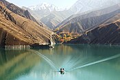
 Kazemi dam from above | |
| Location | Saqqez, Bukan, Iran[1] |
| Coordinates | 36°18′31.27″N 46°30′16.03″E / 36.3086861°N 46.5044528°E |
| Purpose | Power, irrigation |
| Status | Operational |
| Construction began | 1967 |
| Opening date | 1971 |
| Dam and spillways | |
| Type of dam | Dam with clay core |
| Impounds | Zarrineh River |
| Height | 50 m (164 ft) |
| Length | 720 m (2,362 ft) |
| Reservoir | |
| Total capacity | 800,000,000 m3 (648,571 acre⋅ft) |
| Power Station | |
| Installed capacity | 87 MW |
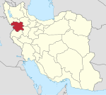
Shahid Kazemi Dam (originally named Kourosh Dam and also known as the Saqqez Lagzi Dam and Bukan Dam)[2] is a clay core dam on the Zarrineh River in the Zagros Mountains range, located near Saqqez[3] in West Azarbaijan Province, Iran.[4]
The crown of this dam is located 25 km Northeast of the border of Kurdistan province and West Azarbaijan Province.[5] The reservoir and lake of the dam are located in Kurdistan province and its catchment area is from Chehel Cheshmeh and Kileh Shin mountains in Zagros mountains between Saqqez and Baneh and Divandarreh.
This Dam was constructed to store water for supplying drinking water to cities, irrigation and produce hydroelectric power.[6]
Geography
In Kazemi Dam Lake, various islands have been formed that are the habitats of animal species, especially a number of rare ones, including species of birds. Larus are one of the most important species of birds that live in the islands and around the lake, which itself has different species. This lake has surprised and delighted people and environmental experts because the habitat of these creatures is mostly on the shores of large seas and lakes.

Nazargah Island is the largest island in the lake. One of the advantages of these islands is the protection of rare bird species from the danger of being hunted by other animals such as wolves, snakes and foxes. Also, millions of fish are raised in this lake every year and are sent to the markets by fishermen during the fishing season.[7]
See also
References
- ^ Evaluation Of The Most Appropriate Statistical Distribution For Monthly Rainfall Prediction In The Zarrineh River Watershed, sciarena
- ^ Shahid Kazemi Dam, Shahid Kazemi Dam
- ^ Breeding biology of Slender-billed Gull (Larus genei Breme 1839) in West Azerbaijan province, Iran, scientific-reports
- ^ The study of Changes in the composition of inorganic compounds of phosphate and nitrate in the lake behind Shahid Kazemi Dam (West Azarbaijan province),Islamic Azad University Ahvaz
- ^ Two dimensional numerical models for reservoir sedimentation of dams, Two dimensional numerical models for reservoir sedimentation of dams
- ^ Shahid Kazemi Dam, Islamic Azad University
- ^ [1], Irna The Islamic Republic News Agency


