Arevik: Difference between revisions
Appearance
Content deleted Content added
Clarityfiend (talk | contribs) replaced hatnote |
GreenC bot (talk | contribs) Reformat 1 archive link. Wayback Medic 2.5 |
||
| Line 35: | Line 35: | ||
== References == |
== References == |
||
*{{GEOnet2|32FA881E73F33774E0440003BA962ED3}} |
*{{GEOnet2|32FA881E73F33774E0440003BA962ED3}} |
||
*[ |
*[http://world-gazetteer.com/wg.php?x=&men=gcis&lng=en&des=wg&srt=npan&col=abcdefghinoq&msz=1500&geo=-17 World Gazeteer: Armenia]{{dead link|date=July 2021|bot=medic}}{{cbignore|bot=medic}} – World-Gazetteer.com |
||
*{{ArmenianCensus|130}} |
*{{ArmenianCensus|130}} |
||
*{{RediscoveringArmenia|39}} |
*{{RediscoveringArmenia|39}} |
||
Revision as of 19:08, 16 July 2021
40°06′02″N 44°05′49″E / 40.10056°N 44.09694°E
Arevik
Արևիկ | |
|---|---|
| Coordinates: 40°06′02″N 44°05′49″E / 40.10056°N 44.09694°E | |
| Country | Armenia |
| Province | Armavir |
| Population (2008) | |
• Total | 2,667 |
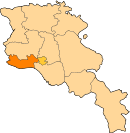
Arevik (Template:Lang-hy; formerly, Agdzharkh and Aghja-Arkh) is a town in the Armavir province of Armenia. The name Arevik comes from the root Arev meaning "sun".
See also
References
- Arevik at GEOnet Names Server
- World Gazeteer: Armenia[dead link] – World-Gazetteer.com
- Report of the results of the 2001 Armenian Census, Statistical Committee of Armenia
- Kiesling, Brady (June 2000). Rediscovering Armenia: An Archaeological/Touristic Gazetteer and Map Set for the Historical Monuments of Armenia (PDF). Archived (PDF) from the original on 6 November 2021.


