Vesala: Difference between revisions
Appearance
Content deleted Content added
m first paragraph |
added geocoord + removed coord missing tag |
||
| Line 61: | Line 61: | ||
|timezone_DST = [[Eastern European Summer Time|EEST]] |
|timezone_DST = [[Eastern European Summer Time|EEST]] |
||
|utc_offset_DST = +3 |
|utc_offset_DST = +3 |
||
|coordinates = |
|coordinates = {{coord|60.24086|25.10289|display=inline,title}} |
||
|elevation_footnotes = <!--for references: use <ref> tags--> |
|elevation_footnotes = <!--for references: use <ref> tags--> |
||
|elevation_m = |
|elevation_m = |
||
| Line 87: | Line 87: | ||
{{Helsinki}} |
{{Helsinki}} |
||
{{SouthernFinland-geo-stub}} |
{{SouthernFinland-geo-stub}} |
||
{{coord missing|Finland}} |
|||
[[Category:Neighbourhoods of Helsinki]] |
[[Category:Neighbourhoods of Helsinki]] |
||
Revision as of 14:28, 17 January 2021
You can help expand this article with text translated from the corresponding article in Finnish. (December 2009) Click [show] for important translation instructions.
|
Vesala (in Finnish) Ärvings (in Swedish) | |
|---|---|
Neighborhood of Helsinki | |
 Location in Helsinki | |
| Coordinates: 60°14′27″N 25°06′10″E / 60.24086°N 25.10289°E | |
| Country | |
| Province | Southern Finland |
| Region | Uusimaa |
| Sub-region | Helsinki |
| Time zone | UTC+2 (EET) |
| • Summer (DST) | UTC+3 (EEST) |
Vesala (Template:Lang-sv) is a neighborhood in eastern Helsinki, Finland. It is a part of the Mellunkylä district.[1][2] The residential housing in the area consists mostly of single-family houses built in the 1950s and 1960s and apartment buildings built in the 1980s.[3]
Gallery
-
Park Aarrepuisto
-
The Kotikonnuntie bridge
-
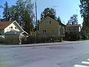
Single-family houses in the neighborhood.
References
- ^ "Alueportaali". www.alueportaali.net. Retrieved 2019-02-25.
- ^ "Mellunkylä". Helsingin kaupunki (in Finnish). Retrieved 2019-02-25.
- ^ "Alueportaali". www.alueportaali.net. Retrieved 2019-02-25.


