Middle America Trench: Difference between revisions
m Open access bot: doi added to citation with #oabot. |
minor formatting |
||
| (2 intermediate revisions by one other user not shown) | |||
| Line 1: | Line 1: | ||
{{short description|Subduction zone in the eastern Pacific off the southwestern coast of |
{{short description|Subduction zone in the eastern Pacific off the southwestern coast of Middle America}} |
||
[[Image:MiddleAmericaTrench.jpg|right|thumb|300px|The trench is colored in dark blue]] |
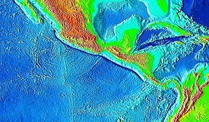
[[Image:MiddleAmericaTrench.jpg|right|thumb|300px|The trench is colored in dark blue, extending from central [[Geography of Mexico|Mexico]] to [[Geography of Costa Rica|Costa Rica]] in the [[Pacific Ocean]] ]] |
||
[[Image:Tectonic plates Caribbean.png|thumb|300px|The trench lies at the convergence of the [[Cocos |
[[Image:Tectonic plates Caribbean.png|thumb|300px|The trench lies at the convergence of the [[Cocos plate|Cocos]], [[Nazca plate|Nazca]], [[North American plate|North American]], and [[Caribbean plate|Caribbean]] plates]] |
||
The '''Middle America Trench''' is a major [[subduction |
The '''Middle America Trench''' is a major [[subduction]] zone, an [[oceanic trench]] in the eastern [[Pacific Ocean]] off the southwestern coast of [[Middle America (Americas)|Middle America]], stretching from central [[Mexico]] to [[Costa Rica]]. The trench is 1,700 miles (2,750 km) long and is 21,880 feet (6,669 m) at its deepest point. |
||
The trench is the boundary between the [[Rivera |
The trench is the boundary between the [[Rivera plate|Rivera]], [[Cocos plate|Cocos]], and [[Nazca plate|Nazca]] plates on one side and the [[North American plate|North American]] and [[Caribbean plate|Caribbean]] plates on the other. It is the 18th-deepest trench in the world. Many large earthquakes have occurred in the area of the Middle America Trench.<ref>{{cite journal|first1=L.|last1=Astiz|first2=H.|last2=Kanamori|authorlink2=Hiroo Kanamori|first3=H.|last3=Eissler|url=http://authors.library.caltech.edu/49188/|title=Source characteristics of earthquakes in the Michoacan seismic gap in Mexico|journal=Bulletin of the Seismological Society of America |year=1987 |volume=77|issue=4 |pages=1326–1346|doi=10.1785/BSSA0770041326 |bibcode=1987BuSSA..77.1326A }}</ref> |
||
==Division== |
==Division== |
||
The Middle America Trench can be divided into a northern and a southern section. The division, however, is not the same in its seaward side and its landward side. In the seaward side, the northern section, called the Acapulco Trench, runs from [[Jalisco]] to the [[Tehuantepec Ridge]], and the southern section, called the Guatemala Trench, runs from the Tehuantepec Ridge to the Cocos Ridge.<ref>{{cite journal|url=http://www.revistas.unam.mx/index.php/geofisica/article/download/39775/36200|title=Sediment Fill |
The Middle America Trench can be divided into a northern and a southern section. The division, however, is not the same in its seaward side and its landward side. In the seaward side, the northern section, called the Acapulco Trench, runs from [[Jalisco]] to the [[Tehuantepec Ridge]], and the southern section, called the Guatemala Trench, runs from the Tehuantepec Ridge to the Cocos Ridge.<ref>{{cite journal|url=http://www.revistas.unam.mx/index.php/geofisica/article/download/39775/36200|title=Sediment Fill in the Middle America Trench Inferred From Gravity Anomalies|journal=Geofísica Internacional|volume=42 |year=2003|pages=603–612|author1=Marina Manea |author2=Vlad C. Manea |author3=Vladimir Kostoglodov |issue=4 |doi=10.22201/igeof.00167169p.2003.42.4.314 |doi-access=free }}</ref> On the landward side, the division is demarcated along the Polochic-Motagua fault system (see [[Motagua Fault]]), the boundary between the North American plate and the Caribbean plate.<ref>{{cite journal|title=Kinematics of the North American–Caribbean-Cocos plates in Central America from new GPS measurements across the Polochic-Motagua fault system|doi=10.1029/2006GL027694|year=2006|last1=Lyon-Caen|first1=H.|last2=Barrier|first2=E.|last3=Lasserre|first3=C.|last4=Franco|first4=A.|last5=Arzu|first5=I.|last6=Chiquin|first6=L.|last7=Chiquin|first7=M.|last8=Duquesnoy|first8=T.|last9=Flores|first9=O.|last10=Galicia|first10=O.|last11=Luna|first11=J.|last12=Molina|first12=E.|last13=Porras|first13=O.|last14=Requena|first14=J.|last15=Robles|first15=V.|last16=Romero|first16=J.|last17=Wolf|first17=R.|journal=Geophysical Research Letters|volume=33|issue=19|pages=19309|bibcode = 2006GeoRL..3319309L |s2cid=3161221 |url=https://hal.archives-ouvertes.fr/hal-02057876/file/Lyon-Caen_et_al-2006-Geophysical_Research_Letters.pdf}}</ref> The dividing point in the landward side is about 400 km east of that in the seaward side.<ref>{{cite report|url=http://www.deepseadrilling.org/67/dsdp_toc.htm |chapter-url=http://www.deepseadrilling.org/67/volume/dsdp67_41.pdf |doi=10.2973/dsdp.proc.67.141.1982|title=Initial Reports of the Deep Sea Drilling Project, 67|chapter=The Middle America Trench in the Geological Framework of Central America |orig-year=1982 |year=2007 |publisher=[[Deep Sea Drilling Project]] |last1=Aubouin|first1=J.|last2=Azema|first2=J.|last3=Carfantan|first3=J.-Ch.|last4=Demant|first4=A.|last5=Rangin|first5=C.|last6=Tardy|first6=M.|last7=Tournon|first7=J.|series=Initial Reports of the Deep Sea Drilling Project |volume=67 |doi-access=free}}</ref> |
||
== References == |
== References == |
||
Latest revision as of 02:02, 9 November 2024


The Middle America Trench is a major subduction zone, an oceanic trench in the eastern Pacific Ocean off the southwestern coast of Middle America, stretching from central Mexico to Costa Rica. The trench is 1,700 miles (2,750 km) long and is 21,880 feet (6,669 m) at its deepest point. The trench is the boundary between the Rivera, Cocos, and Nazca plates on one side and the North American and Caribbean plates on the other. It is the 18th-deepest trench in the world. Many large earthquakes have occurred in the area of the Middle America Trench.[1]
Division
[edit]The Middle America Trench can be divided into a northern and a southern section. The division, however, is not the same in its seaward side and its landward side. In the seaward side, the northern section, called the Acapulco Trench, runs from Jalisco to the Tehuantepec Ridge, and the southern section, called the Guatemala Trench, runs from the Tehuantepec Ridge to the Cocos Ridge.[2] On the landward side, the division is demarcated along the Polochic-Motagua fault system (see Motagua Fault), the boundary between the North American plate and the Caribbean plate.[3] The dividing point in the landward side is about 400 km east of that in the seaward side.[4]
References
[edit]- ^ Astiz, L.; Kanamori, H.; Eissler, H. (1987). "Source characteristics of earthquakes in the Michoacan seismic gap in Mexico". Bulletin of the Seismological Society of America. 77 (4): 1326–1346. Bibcode:1987BuSSA..77.1326A. doi:10.1785/BSSA0770041326.
- ^ Marina Manea; Vlad C. Manea; Vladimir Kostoglodov (2003). "Sediment Fill in the Middle America Trench Inferred From Gravity Anomalies". Geofísica Internacional. 42 (4): 603–612. doi:10.22201/igeof.00167169p.2003.42.4.314.
- ^ Lyon-Caen, H.; Barrier, E.; Lasserre, C.; Franco, A.; Arzu, I.; Chiquin, L.; Chiquin, M.; Duquesnoy, T.; Flores, O.; Galicia, O.; Luna, J.; Molina, E.; Porras, O.; Requena, J.; Robles, V.; Romero, J.; Wolf, R. (2006). "Kinematics of the North American–Caribbean-Cocos plates in Central America from new GPS measurements across the Polochic-Motagua fault system" (PDF). Geophysical Research Letters. 33 (19): 19309. Bibcode:2006GeoRL..3319309L. doi:10.1029/2006GL027694. S2CID 3161221.
- ^ Aubouin, J.; Azema, J.; Carfantan, J.-Ch.; Demant, A.; Rangin, C.; Tardy, M.; Tournon, J. (2007) [1982]. "The Middle America Trench in the Geological Framework of Central America" (PDF). Initial Reports of the Deep Sea Drilling Project, 67 (Report). Initial Reports of the Deep Sea Drilling Project. Vol. 67. Deep Sea Drilling Project. doi:10.2973/dsdp.proc.67.141.1982.
