Schwarzenburg District: Difference between revisions
Appearance
Content deleted Content added
m upd. template |
use wikitable |
||
| (25 intermediate revisions by 21 users not shown) | |||
| Line 1: | Line 1: | ||
{{Infobox settlement |
|||
| ⚫ | |||
| official_name = Schwarzenburg District |
|||
| native_name = Amtsbezirk Schwarzenburg |
|||
| settlement_type = District |
|||
| image_map = Karte Bezirk Schwarzenburg 2007.png |
|||
| subdivision_type = [[Countries of the world|Country]] |
|||
| subdivision_name = {{CHE}} |
|||
| subdivision_type2 = [[Cantons of Switzerland|Canton]] |
|||
| subdivision_name2 = {{Flag|Bern}} |
|||
| subdivision_type3 = Capital |
|||
| subdivision_name3 = [[Wahlern]] |
|||
| area_total_km2 = 157 |
|||
| area_footnotes = |
|||
| population_as_of = 2007 |
|||
| population_total = 10002 |
|||
| population_footnotes = |
|||
| population_density_km2 = auto |
|||
| timezone = [[Central European Time|CET]] |
|||
| utc_offset = +1 |
|||
| timezone_DST = [[Central European Summer Time|CEST]] |
|||
| utc_offset_DST = +2 |
|||
| blank_name_sec1 = Municipalities |
|||
| blank_info_sec1 = 4 |
|||
}} |
|||
| ⚫ | |||
From 1 January 2010, the district lost its administrative power while being replaced by the [[Bern-Mittelland (administrative district)]], whose administrative centre is Ostermundigen. |
|||
<div style="padding:1em 20px 1em 20px; color:#000000;text-align:left;"> |
|||
{| cellpadding="3" cellspacing="0" border="1" style="border: gray solid 1px; border-collapse: collapse;" |
|||
Since 2010, it remains therefore a fully recognised district under the law and the Constitution (Art.3 al.2) of the Canton of Berne. |
|||
!colspan="1" align=left bgcolor="#EFEFEF" width="190" | '''Municipality''' |
|||
!colspan="1" align=center bgcolor="#EFEFEF" width="140" | '''Population '''<small>(Jan 2005)</small> |
|||
The district has an area of 157 km<sup>2</sup> and consisted of 4 [[Municipalities of the canton of Bern|municipalities]]: |
|||
!colspan="1" align=center bgcolor="#EFEFEF" width="100" | '''Area (km²)''' |
|||
{| class="wikitable" |
|||
!width="190" | Municipality |
|||
!width="140" | Population <small>(Dec 2007)<ref name=SFSO>[http://www.bfs.admin.ch/bfs/portal/en/index/regionen/regionalportraets/gemeindesuche.html Swiss Federal Statistical Office] {{webarchive|url=https://web.archive.org/web/20110904041839/http://www.bfs.admin.ch/bfs/portal/en/index/regionen/regionalportraets/gemeindesuche.html |date=2011-09-04 }} accessed 13-Jul-2009</ref></small> |
|||
!width="100" | Area (km<sup>2</sup>) |
|||
|- |
|- |
||
| [[Albligen]] || align="center" | |
| [[Albligen]] || align="center" | 465 || align="center" | 4.3 |
||
|- |
|- |
||
| [[Guggisberg]] || align="center" | 1, |
| [[Guggisberg]] || align="center" | 1,602 || align="center" | 54.9 |
||
|- |
|- |
||
| [[Rüschegg]] || align="center" | 1, |
| [[Rüschegg]] || align="center" | 1,708 || align="center" | 57.4 |
||
|- |
|- |
||
| [[Wahlern]] || align="center" | 6, |
| [[Wahlern]] || align="center" | 6,227 || align="center" | 40.6 |
||
|} |
|} |
||
</div> |
|||
==References== |
|||
{{reflist}} |
|||
{{Canton Berne}} |
{{Canton Berne}} |
||
{{coord|46|49|N|7|21|E|region:CH|display=title}} |
|||
[[Category:Former districts of the canton of Bern]] |
|||
{{Berne-geo-stub}} |
{{Berne-geo-stub}} |
||
[[Category:Districts of Switzerland]] |
|||
<!-- Interwiki --> |
|||
[[de:Schwarzenburg (Bezirk)]] |
|||
[[es:Distrito de Schwarzenburg]] |
|||
[[fr:District de Schwarzenburg]] |
|||
[[it:Schwarzenburg]] |
|||
[[nl:Schwarzenburg (district)]] |
|||
[[sv:Schwarzenburg (amtsbezirk, CH-BE)]] |
|||
Latest revision as of 12:45, 8 November 2024
Schwarzenburg District
Amtsbezirk Schwarzenburg | |
|---|---|
District | |
 | |
| Country | |
| Canton | |
| Capital | Wahlern |
| Area | |
• Total | 157 km2 (61 sq mi) |
| Population (2007) | |
• Total | 10,002 |
| • Density | 64/km2 (170/sq mi) |
| Time zone | UTC+1 (CET) |
| • Summer (DST) | UTC+2 (CEST) |
| Municipalities | 4 |
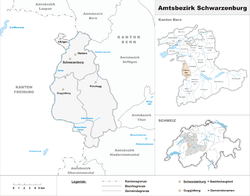
Schwarzenburg District is one of the 26 administrative districts in the Canton of Bern, Switzerland. Its capital, while having administrative power, was the town of Schwarzenburg, located in the municipality of Wahlern.
From 1 January 2010, the district lost its administrative power while being replaced by the Bern-Mittelland (administrative district), whose administrative centre is Ostermundigen.
Since 2010, it remains therefore a fully recognised district under the law and the Constitution (Art.3 al.2) of the Canton of Berne.
The district has an area of 157 km2 and consisted of 4 municipalities:
| Municipality | Population (Dec 2007)[1] | Area (km2) |
|---|---|---|
| Albligen | 465 | 4.3 |
| Guggisberg | 1,602 | 54.9 |
| Rüschegg | 1,708 | 57.4 |
| Wahlern | 6,227 | 40.6 |
References
[edit]- ^ Swiss Federal Statistical Office Archived 2011-09-04 at the Wayback Machine accessed 13-Jul-2009
46°49′N 7°21′E / 46.817°N 7.350°E
