Vesala: Difference between revisions
Appearance
Content deleted Content added
m r2.7.1) (Robot: Adding fr:Vesala |
|||
| (10 intermediate revisions by 9 users not shown) | |||
| Line 1: | Line 1: | ||
{{About|the neighborhood of Helsinki|the surname|Vesala (surname)}} |
|||
{{Expand Finnish|topic=geo|date=December 2009}} |
{{Expand Finnish|topic=geo|date=December 2009|Vesala}} |
||
{{Infobox settlement |
{{Infobox settlement |
||
<!--See the Table at Infobox Settlement for all fields and descriptions of usage--> |
<!--See the Table at Infobox Settlement for all fields and descriptions of usage--> |
||
<!-- Basic info ----------------> |
<!-- Basic info ----------------> |
||
|official_name =Vesala {{ |
|official_name = Vesala {{in lang|fi}}<br/>Ärvings {{in lang|sv}} |
||
|other_name = |
|other_name = |
||
|native_name = <!-- for cities whose native name is not in English --> |
|native_name = <!-- for cities whose native name is not in English --> |
||
|nickname = |
|nickname = |
||
|settlement_type =Neighborhood of Helsinki |
|settlement_type = Neighborhood of Helsinki |
||
|motto = |
|motto = |
||
<!-- images and maps -----------> |
<!-- images and maps -----------> |
||
| Line 21: | Line 22: | ||
|map_caption = Location in Helsinki |
|map_caption = Location in Helsinki |
||
|pushpin_map = |
|pushpin_map = |
||
|pushpin_label_position =bottom |
|pushpin_label_position = bottom |
||
|pushpin_mapsize=300 |
|pushpin_mapsize=300 |
||
|pushpin_map_caption = |
|pushpin_map_caption = |
||
|subdivision_type = Country |
|subdivision_type = Country |
||
|subdivision_name ={{flag|Finland}} |
|subdivision_name = {{flag|Finland}} |
||
|subdivision_type1 = [[Provinces of Finland|Province]] |
|subdivision_type1 = [[Provinces of Finland|Province]] |
||
|subdivision_name1 =[[Southern Finland]] |
|subdivision_name1 = [[Southern Finland]] |
||
|subdivision_type2 = [[Regions of Finland|Region]] |
|subdivision_type2 = [[Regions of Finland|Region]] |
||
|subdivision_name2 =[[Uusimaa]] |
|subdivision_name2 = [[Uusimaa]] |
||
|subdivision_type3 = [[Sub-regions of Finland|Sub-region]] |
|subdivision_type3 = [[Sub-regions of Finland|Sub-region]] |
||
|subdivision_name3 = Helsinki |
|subdivision_name3 = Helsinki |
||
| Line 45: | Line 46: | ||
<!-- Area ---------------------> |
<!-- Area ---------------------> |
||
|area_magnitude = |
|area_magnitude = |
||
|unit_pref =Imperial <!--Enter: Imperial, if Imperial (metric) is desired--> |
|unit_pref = Imperial <!--Enter: Imperial, if Imperial (metric) is desired--> |
||
|area_footnotes = |
|area_footnotes = |
||
|area_total_km2 = |
|area_total_km2 = |
||
| Line 57: | Line 58: | ||
<!-- General information ---------------> |
<!-- General information ---------------> |
||
|timezone = [[Eastern European Time|EET]] |
|timezone = [[Eastern European Time|EET]] |
||
|utc_offset = |
|utc_offset = +2 |
||
|timezone_DST = [[Eastern European Summer Time|EEST]] |
|timezone_DST = [[Eastern European Summer Time|EEST]] |
||
|utc_offset_DST = +3 |
|utc_offset_DST = +3 |
||
|coordinates = {{coord|60.24086|25.10289|display=inline,title}} |
|||
|latd=|latm= |lats= |latNS=N |
|||
|longd=|longm=|longs=|longEW=E |
|||
|elevation_footnotes = <!--for references: use <ref> tags--> |
|elevation_footnotes = <!--for references: use <ref> tags--> |
||
|elevation_m = |
|elevation_m = |
||
| Line 74: | Line 74: | ||
|footnotes = |
|footnotes = |
||
}} |
}} |
||
'''Vesala''' ({{langx|sv|Ärvings}}) is a neighborhood in eastern [[Helsinki]], [[Finland]]. It is a part of the [[Mellunkylä]] district.<ref>{{Cite web|url=http://www.alueportaali.net/alueet.html|title=Alueportaali|website=www.alueportaali.net|access-date=2019-02-25}}</ref><ref>{{Cite web|url=https://www.hel.fi/helsinki/fi/kaupunki-ja-hallinto/hallinto/kaupunginosat/mellunkyla|title=Mellunkylä|website=Helsingin kaupunki|language=fi|access-date=2019-02-25}}</ref> The residential housing in the area consists mostly of single-family houses built in the 1950s and 1960s and apartment buildings built in the 1980s.<ref>{{Cite web|url=http://www.alueportaali.net/alueet/vesala.html|title=Alueportaali|website=www.alueportaali.net|access-date=2019-02-25}}</ref> |
|||
'''Vesala''' ([[Finnish language|Finnish]]), '''Ärvings''' ([[Swedish language|Swedish]]) is an eastern neighborhood of [[Helsinki]], [[Finland]]. |
|||
== Gallery == |
|||
<gallery widths="180" heights="180"> |
|||
File:Aarrepuisto puro nauhukset.jpg|Park Aarrepuisto |
|||
File:Kotikonnuntien silta - panoramio.jpg|The Kotikonnuntie bridge |
|||
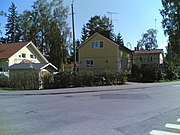
File:Koskenhaantie ja Paneliantie - panoramio.jpg|Single-family houses in the neighborhood. |
|||
</gallery> |
|||
== References == |
|||
{{Reflist}} |
|||
| ⚫ | |||
{{Helsinki}} |
{{Helsinki}} |
||
| ⚫ | |||
{{coord missing|Finland}} |
|||
[[Category:Neighbourhoods of Helsinki]] |
[[Category:Neighbourhoods of Helsinki]] |
||
[[fr:Vesala]] |
|||
[[fi:Vesala]] |
|||
[[sv:Ärvings]] |
|||
Latest revision as of 18:25, 29 October 2024
You can help expand this article with text translated from the corresponding article in Finnish. (December 2009) Click [show] for important translation instructions.
|
Vesala (in Finnish) Ärvings (in Swedish) | |
|---|---|
Neighborhood of Helsinki | |
 Location in Helsinki | |
| Coordinates: 60°14′27″N 25°06′10″E / 60.24086°N 25.10289°E | |
| Country | |
| Province | Southern Finland |
| Region | Uusimaa |
| Sub-region | Helsinki |
| Time zone | UTC+2 (EET) |
| • Summer (DST) | UTC+3 (EEST) |
Vesala (Swedish: Ärvings) is a neighborhood in eastern Helsinki, Finland. It is a part of the Mellunkylä district.[1][2] The residential housing in the area consists mostly of single-family houses built in the 1950s and 1960s and apartment buildings built in the 1980s.[3]
Gallery
[edit]-
Park Aarrepuisto
-
The Kotikonnuntie bridge
-
Single-family houses in the neighborhood.
References
[edit]- ^ "Alueportaali". www.alueportaali.net. Retrieved 2019-02-25.
- ^ "Mellunkylä". Helsingin kaupunki (in Finnish). Retrieved 2019-02-25.
- ^ "Alueportaali". www.alueportaali.net. Retrieved 2019-02-25.


