Knott End-on-Sea: Difference between revisions
→External links: add navbox |
m Updated link to Blackpool Transport's Webpage for the 5C service - as the former link was outdated and not working. |
||
| (46 intermediate revisions by 28 users not shown) | |||
| Line 1: | Line 1: | ||
{{Use dmy dates|date=April 2015}} |
|||
{{Use British English|date=April 2015}} |
|||
{{Infobox UK place | |
{{Infobox UK place | |
||
|country = England |
|country = England |
||
|official_name= Knott End-on-Sea |
|official_name= Knott End-on-Sea |
||
| |
|local_name= Knott End |
||
|coordinates = {{coord|53.926|-2.979|display=inline,title}} |
|||
|longitude= -2.97917 |
|||
|static_image_name = Knott End Methodist Church - geograph.org.uk - 1758574.jpg |
|||
|map_type= Lancashire |
|||
|static_image_caption = Knott End Methodist Church |
|||
|civil_parish= Preesall |
|civil_parish= [[Preesall]] |
||
|population = |
|population = |
||
|shire_district= [[Wyre]] |
|shire_district= [[Borough of Wyre|Wyre]] |
||
|shire_county= [[Lancashire]] |
|shire_county= [[Lancashire]] |
||
| |
|region = North West England |
||
|constituency_westminster= [[Lancaster and |
|constituency_westminster= [[Lancaster and Fleetwood (UK Parliament constituency)|Lancaster and Fleetwood]] |
||
|post_town= POULTON-LE-FYLDE |
|post_town= POULTON-LE-FYLDE |
||
|postcode_district= FY6 |
|postcode_district= FY6 |
||
|postcode_area= FY |
|postcode_area= FY |
||
|dial_code= |
|dial_code= 01253 |
||
|os_grid_reference= SD358483 |
|os_grid_reference= SD358483 |
||
|pushpin_map = United Kingdom Borough of Wyre#United Kingdom The Fylde#United Kingdom Morecambe Bay |
|||
|pushpin_map_caption = Location in Wyre Borough##Location on the Fylde##Location on Morecambe Bay |
|||
}} |
}} |
||
| ⚫ | '''Knott End-on-Sea''' is a village in [[Lancashire]], |
||
| ⚫ | '''Knott End-on-Sea''' is a village in [[Lancashire]], England, on the southern side of [[Morecambe Bay]], across the [[River Wyre|Wyre estuary]] from [[Fleetwood]]. Knott End has a pub, the Bourne Arms, county library and golf club. Buses run regularly from Knott End and there is also a [[Fleetwood-to-Knott End ferry|three-minute ferry crossing to Fleetwood]]. |
||
| ⚫ | |||
| ⚫ | |||
== Public transport == |
|||
Knott End is serviced by [[Blackpool Transport]]'s route 5C, which loops between the village and [[Blackpool]] town centre via Poulton-le-Fylde.<ref>[https://www.blackpooltransport.com/routes/BLAC/5c 5C Knott End to Blackpool - Blackpool Transport]</ref> [[Archway Travel]]'s number 567 runs between Knott End and schools in [[Lancaster, Lancashire|Lancaster]],<ref>{{Cite web |date=2019-06-03 |title=School Bus route 567 - Archway Travel |url=https://archwaytravel.co.uk/route-567/ |access-date=2023-10-25 |language=en-GB}}</ref> while the 541 passes through [[Pilling]] to [[Hodgson Academy]] and Baines High School in Poulton.<ref>{{Cite web |date=2018-06-17 |title=School Bus route 541 - Archway Travel |url=https://archwaytravel.co.uk/route-541/ |access-date=2023-10-25 |language=en-GB}}</ref> |
|||
School services are also provided by Kirkby Lonsdale Coach Hire's routes 88 and 89.<ref>{{Cite web |title=88, 89 |url=https://klch.co.uk/bus-services/timetable-89-lancaster-knott-end-service |access-date=2023-11-06 |website=klch.co.uk}}</ref> |
|||
[[File:Blackpool_Transport_291_YJ07EJK_(9126098666).jpg|thumb|An [[Optare Solo]] M950 running the 2C route between Knott-End-on-Sea and [[Blackpool]] town centre in 2013]] |
|||
==See also== |
==See also== |
||
*[[Knott End Railway]] |
*[[Garstang and Knot-End Railway|Knott End Railway]] |
||
*[[Knott End-on-Sea railway station]] |
*[[Knott End-on-Sea railway station]] |
||
==References== |
|||
{{reflist}} |
|||
==External links== |
==External links== |
||
*{{commonscat-inline}} |
|||
{{Commons category|Knott End-on-Sea}} |
|||
* [http://www.lancashireparishcouncils.gov.uk/parishes/parish_display.asp?parishid=63 Preesall Town Council] |
|||
* [http://wyrebc.gov.uk/ Wyre Borough Council] |
|||
* [http://www.lancashire.gov.uk/home/index.asp/ Lancashire County Council] |
|||
* [http://www.lancslinks.org.uk/linkscontent/mycommunity/localcommunity/wyre/knottend/ Local Information] |
|||
* [http://www.OverWyre.info Over-Wyre and Knott End History and Topography] |
|||
* [http://www.OverWyre.info L S Lowry in Knott End] accessed 31 August 2009 |
|||
{{Borough of Wyre}} |
{{Borough of Wyre}} |
||
{{authority control}} |
|||
[[Category:Villages in Lancashire]] |
[[Category:Villages in Lancashire]] |
||
[[Category:Geography of Wyre]] |
[[Category:Geography of the Borough of Wyre]] |
||
[[Category:The Fylde]] |
[[Category:The Fylde]] |
||
[[Category:Populated coastal places in Lancashire]] |
[[Category:Populated coastal places in Lancashire]] |
||
[[Category:Morecambe Bay]] |
[[Category:Morecambe Bay]] |
||
{{Lancashire-geo-stub}} |
{{Lancashire-geo-stub}} |
||
[[pl:Knott End-on-Sea]] |
|||
Latest revision as of 15:56, 21 January 2024
Knott End-on-Sea
| |
|---|---|
 Knott End Methodist Church | |
Location within Lancashire | |
| OS grid reference | SD358483 |
| Civil parish | |
| District | |
| Shire county | |
| Region | |
| Country | England |
| Sovereign state | United Kingdom |
| Post town | POULTON-LE-FYLDE |
| Postcode district | FY6 |
| Dialling code | 01253 |
| Police | Lancashire |
| Fire | Lancashire |
| Ambulance | North West |
| UK Parliament | |
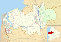
Knott End-on-Sea is a village in Lancashire, England, on the southern side of Morecambe Bay, across the Wyre estuary from Fleetwood. Knott End has a pub, the Bourne Arms, county library and golf club. Buses run regularly from Knott End and there is also a three-minute ferry crossing to Fleetwood.
Knott End also has two clubs: The Squash and Knott End Working Men's Club.
Public transport
[edit]Knott End is serviced by Blackpool Transport's route 5C, which loops between the village and Blackpool town centre via Poulton-le-Fylde.[1] Archway Travel's number 567 runs between Knott End and schools in Lancaster,[2] while the 541 passes through Pilling to Hodgson Academy and Baines High School in Poulton.[3]
School services are also provided by Kirkby Lonsdale Coach Hire's routes 88 and 89.[4]

See also
[edit]References
[edit]- ^ 5C Knott End to Blackpool - Blackpool Transport
- ^ "School Bus route 567 - Archway Travel". 3 June 2019. Retrieved 25 October 2023.
- ^ "School Bus route 541 - Archway Travel". 17 June 2018. Retrieved 25 October 2023.
- ^ "88, 89". klch.co.uk. Retrieved 6 November 2023.
External links
[edit] Media related to Knott End-on-Sea at Wikimedia Commons


