Puerto Rico Highway 6685: Difference between revisions
Appearance
Content deleted Content added
→Gallery: + image |
→Major intersections: Upd gallery format |
||
| (22 intermediate revisions by 2 users not shown) | |||
| Line 1: | Line 1: | ||
{{ |
{{Short description|Highway in Puerto Rico}} |
||
{{ |
{{Use dmy dates|date=August 2019}} |
||
{{Infobox road |
{{Infobox road |
||
|state=PR |
|state=PR |
||
| Line 10: | Line 10: | ||
|length_ref=<ref name=google/> |
|length_ref=<ref name=google/> |
||
|direction_a=South |
|direction_a=South |
||
|terminus_a={{ |
|terminus_a={{jct|state=PR|Sec|146}} in [[Hato Viejo, Ciales, Puerto Rico|Hato Viejo]]–[[Cordillera, Ciales, Puerto Rico|Cordillera]] |
||
|junction |
|junction= |
||
*{{ |
* {{jct|state=PR|Ter|632}} in Hato Viejo |
||
*{{ |
* {{jct|state=PR|Sec|6633}} in Hato Viejo |
||
*{{ |
* {{jct|state=PR|Ter|643}} in [[Río Arriba Saliente]] |
||
*{{ |
* {{jct|state=PR|Sec|642}} in Río Arriba Saliente |
||
}} |
|||
|direction_b=North |
|direction_b=North |
||
|terminus_b={{ |
|terminus_b={{jct|state=PR|Sec|2}} in [[Manatí barrio-pueblo]] |
||
|municipalities=[[Ciales, Puerto Rico|Ciales]], [[Manatí, Puerto Rico|Manatí]] |
|municipalities=[[Ciales, Puerto Rico|Ciales]], [[Manatí, Puerto Rico|Manatí]] |
||
|previous_type=Sec |
|previous_type=Sec |
||
|previous_route=6633 |
|previous_route=6633 |
||
|next_type=Ter |
|next_type=Ter |
||
|next_route= |
|next_route=6690 |
||
}} |
}} |
||
'''Puerto Rico Highway 6685 (PR-6685)''' is a rural highway in Puerto Rico that runs south to north, connecting the towns of [[Ciales, Puerto Rico|Ciales]] and [[Manatí, Puerto Rico|Manatí]] on Puerto Rico's north coast.<ref name="6685 Ciales">{{cite web |title=PR-6685, Ciales, Puerto Rico |url=http://pr.geoview.info/pr6685,22144643w |website=geoview.info |access-date=February 28, 2020}}</ref> It runs slightly parallel to [[Puerto Rico Highway 149]] until it ends at [[Puerto Rico Highway 2]] in Manatí.<ref name="6685 Manatí">{{cite web |title=PR-6685, Manatí, Puerto Rico |url=http://pr.geoview.info/pr6685,22187612w |website=geoview.info |access-date=February 28, 2020}}</ref> It has a junction with PR-149 in Ciales and with Puerto Rico Highway 642 in [[Río Arriba Saliente]], in Manatí.<ref name="NGAdvMap">{{cite map |author=National Geographic Maps |year=2011 |title=Puerto Rico |scale=1:125,000 |series=Adventure Map (Book 3107) |location=Evergreen, Colorado |publisher=National Geographic Maps |isbn=978-1566955188 |oclc=756511572}}</ref> |
'''Puerto Rico Highway 6685 (PR-6685)''' is a rural highway in Puerto Rico that runs south to north, connecting the towns of [[Ciales, Puerto Rico|Ciales]] and [[Manatí, Puerto Rico|Manatí]] on Puerto Rico's north coast.<ref name="6685 Ciales">{{cite web |title=PR-6685, Ciales, Puerto Rico |url=http://pr.geoview.info/pr6685,22144643w |website=geoview.info |access-date=February 28, 2020}}</ref> It runs slightly parallel to [[Puerto Rico Highway 149]] until it ends at [[Puerto Rico Highway 2]] in Manatí.<ref name="6685 Manatí">{{cite web |title=PR-6685, Manatí, Puerto Rico |url=http://pr.geoview.info/pr6685,22187612w |website=geoview.info |access-date=February 28, 2020}}</ref> It has a junction with PR-149 in Ciales and with Puerto Rico Highway 642 in [[Río Arriba Saliente]] [[Barrios of Puerto Rico|barrio]], in Manatí.<ref name="NGAdvMap">{{cite map |author=National Geographic Maps |year=2011 |title=Puerto Rico |scale=1:125,000 |series=Adventure Map (Book 3107) |location=Evergreen, Colorado |publisher=National Geographic Maps |isbn=978-1566955188 |oclc=756511572}}</ref> |
||
<gallery mode=packed heights=150px caption="Puerto Rico Highway 6685 by municipality"> |
|||
Carretera PR-6685, Manatí, Puerto Rico.jpg|Northern terminus at PR-2 junction in [[Manatí barrio-pueblo|downtown Manatí]], looking south |
|||
Carretera PR-6685, Ciales, Puerto Rico (1).jpg|Heading north between [[Cordillera, Ciales, Puerto Rico|Cordillera]] and [[Hato Viejo, Ciales, Puerto Rico|Hato Viejo]] barrios in Ciales |
|||
| ⚫ | |||
==Major intersections== |
==Major intersections== |
||
<gallery class=center> |
|||
Carretera PR-2, intersección con la carretera PR-6685, Manatí, Puerto Rico.jpg|PR-2 east near the northern terminus of PR-6685 in downtown Manatí |
|||
| ⚫ | |||
| ⚫ | |||
</gallery> |
|||
{{PRinttop|length_ref=<ref name=google>{{google maps|url=https://www.google.com/maps/dir/18.4284111,-66.4954782/18.3432937,-66.4706021/@18.3858492,-66.5186667,13z/data=!3m1!4b1!4m9!4m8!1m5!3m4!1m2!1d-66.4785568!2d18.3586317!3s0x8c0323abda58bd65:0xa7a4da532aacd477!1m0!3e0|title=PR-6685|access-date=February 28, 2020}}</ref>}} |
{{PRinttop|length_ref=<ref name=google>{{google maps|url=https://www.google.com/maps/dir/18.4284111,-66.4954782/18.3432937,-66.4706021/@18.3858492,-66.5186667,13z/data=!3m1!4b1!4m9!4m8!1m5!3m4!1m2!1d-66.4785568!2d18.3586317!3s0x8c0323abda58bd65:0xa7a4da532aacd477!1m0!3e0|title=PR-6685|access-date=February 28, 2020}}</ref>}} |
||
{{PRint |
{{PRint |
||
| Line 79: | Line 91: | ||
{{jctbtm}} |
{{jctbtm}} |
||
== |
==See also== |
||
| ⚫ | |||
<gallery mode=packed heights="170px"> |
|||
* {{Portal-inline|U.S. Roads}} |
|||
| ⚫ | |||
| ⚫ | |||
Barrio Río Arriba Saliente, Manatí, Puerto Rico from bridge on PR-642.jpg|Río Arriba Saliente barrio in Manatí from bridge on PR-642 |
|||
| ⚫ | |||
==References== |
==References== |
||
| Line 90: | Line 99: | ||
==External links== |
==External links== |
||
| ⚫ | |||
| ⚫ | |||
| ⚫ | |||
[[Category:Highways in Puerto Rico|6685]] |
[[Category:Highways in Puerto Rico|6685]] |
||
Latest revision as of 03:48, 6 January 2024
| Ruta 6685 | ||||
| Route information | ||||
| Maintained by Puerto Rico DTPW | ||||
| Length | 11.9 km[1] (7.4 mi) | |||
| Major junctions | ||||
| South end | ||||
| ||||
| North end | ||||
| Location | ||||
| Country | United States | |||
| Territory | Puerto Rico | |||
| Municipalities | Ciales, Manatí | |||
| Highway system | ||||
| ||||
Puerto Rico Highway 6685 (PR-6685) is a rural highway in Puerto Rico that runs south to north, connecting the towns of Ciales and Manatí on Puerto Rico's north coast.[2] It runs slightly parallel to Puerto Rico Highway 149 until it ends at Puerto Rico Highway 2 in Manatí.[3] It has a junction with PR-149 in Ciales and with Puerto Rico Highway 642 in Río Arriba Saliente barrio, in Manatí.[4]
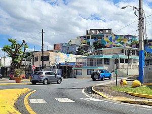
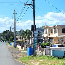
- Puerto Rico Highway 6685 by municipality
-
Northern terminus at PR-2 junction in downtown Manatí, looking south
-
Heading north between Cordillera and Hato Viejo barrios in Ciales
Major intersections
[edit]-
PR-2 east near the northern terminus of PR-6685 in downtown Manatí
-
PR-6685 heading north to PR-2 at PR-642 intersection in Río Arriba Saliente, Manatí
-
Signs for PR-6685 south and north at the western terminus of PR-643 in Río Arriba Saliente, Manatí
| Municipality | Location | km[1] | mi | Destinations | Notes |
|---|---|---|---|---|---|
| Ciales | Hato Viejo–Cordillera line | 11.9 | 7.4 | Southern terminus of PR-6685 | |
| Hato Viejo | 10.1 | 6.3 | |||
| 9.8– 9.7 | 6.1– 6.0 | Puente Mata de Plátano over the Río Grande de Manatí[5] | |||
| 8.8 | 5.5 | ||||
| Manatí | Río Arriba Saliente | 6.6 | 4.1 | ||
| 4.4 | 2.7 | ||||
| Manatí barrio-pueblo | 0.0 | 0.0 | Northern terminus of PR-6685 | ||
| 1.000 mi = 1.609 km; 1.000 km = 0.621 mi | |||||
See also
[edit]References
[edit]- ^ a b "PR-6685" (Map). Google Maps. Retrieved 28 February 2020.
- ^ "PR-6685, Ciales, Puerto Rico". geoview.info. Retrieved 28 February 2020.
- ^ "PR-6685, Manatí, Puerto Rico". geoview.info. Retrieved 28 February 2020.
- ^ National Geographic Maps (2011). Puerto Rico (Map). 1:125,000. Adventure Map (Book 3107). Evergreen, Colorado: National Geographic Maps. ISBN 978-1566955188. OCLC 756511572.
- ^ Luis F. Pumarada O’Neill (1991). "Los Puentes Históricos de Puerto Rico" (PDF) (in Spanish). pp. 99–100. Retrieved 10 March 2020.
External links
[edit] Media related to Puerto Rico Highway 6685 at Wikimedia Commons


