Goodland, Iron County, Missouri: Difference between revisions
Appearance
Content deleted Content added
m copyedit, refine cat, and AWB general fixes, replaced: [[Category: → [[Category:Unincorporated communities in (2), removed: Category:Unincorporated communities in Unincorporated communities in Missouri using AWB |
add "use mdy dates" template |
||
| (14 intermediate revisions by 13 users not shown) | |||
| Line 1: | Line 1: | ||
{{Short description|Unincorporated community in the American state of Missouri}} |
|||
{{Unreferenced|date=December 2009}} |
|||
{{Use mdy dates|date=July 2023}} |
|||
| ⚫ | |||
{{Infobox settlement |
|||
| ⚫ | '''Goodland''' is an [[unincorporated area|unincorporated community]] in western [[Iron County, Missouri|Iron County]], [[Missouri]], |
||
| ⚫ | |||
|settlement_type = [[Unincorporated area|Unincorporated community]] |
|||
|nickname = |
|||
|motto = |
|||
<!-- Images --> |
|||
|image_skyline = |
|||
|imagesize = |
|||
|image_caption = |
|||
|image_flag = |
|||
|image_seal = |
|||
<!-- Maps --> |
|||
| ⚫ | |||
|mapsize = |
|||
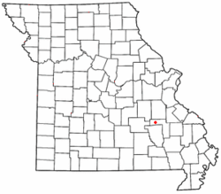
|map_caption = Location of Goodland within Missouri |
|||
|image_map1 = |
|||
|mapsize1 = |
|||
|map_caption1 = |
|||
<!-- Location --> |
|||
|subdivision_type = [[List of sovereign states|Country]] |
|||
|subdivision_name = United States |
|||
|subdivision_type1 = [[U.S. state|State]] |
|||
|subdivision_name1 = [[Missouri]] |
|||
|subdivision_type2 = [[List of counties in Missouri|County]] |
|||
|subdivision_name2 = [[Iron County, Missouri|Iron]] |
|||
<!-- Government --> |
|||
|government_footnotes = |
|||
|government_type = |
|||
|leader_title = |
|||
|leader_name = |
|||
|leader_title1 = |
|||
|leader_name1 = |
|||
|established_title = |
|||
|established_date = |
|||
<!-- Area --> |
|||
|unit_pref = |
|||
|area_footnotes = |
|||
|area_magnitude = |
|||
|area_total_km2 = |
|||
|area_land_km2 = |
|||
|area_water_km2 = |
|||
|area_total_sq_mi = |
|||
|area_land_sq_mi = |
|||
|area_water_sq_mi = |
|||
<!-- Population --> |
|||
|population_as_of = |
|||
|population_footnotes = |
|||
|population_total = |
|||
|population_density_km2 = |
|||
|population_density_sq_mi = |
|||
<!-- General information --> |
|||
|timezone = [[Central Time Zone|Central (CST)]] |
|||
|utc_offset = -6 |
|||
|timezone_DST = CDT |
|||
|utc_offset_DST = -5 |
|||
|elevation_footnotes = |
|||
|elevation_m = |
|||
|elevation_ft = 951 |
|||
|coordinates = {{coord|37.636|-91.003|type:city_region:US-MO|display=inline,title}} |
|||
<!-- Area/postal codes & others --> |
|||
|postal_code_type = |
|||
|postal_code = |
|||
|area_code = [[Area code 573|573]] |
|||
|blank_name = [[Geographic Names Information System|GNIS]] feature ID |
|||
|blank_info = 750074<ref name="gnis"/> |
|||
|blank1_name = |
|||
|blank1_info = |
|||
|website = |
|||
|footnotes = |
|||
}} |
|||
| ⚫ | '''Goodland''' is an [[unincorporated area|unincorporated community]] in western [[Iron County, Missouri|Iron County]], [[Missouri]], United States.<ref name="gnis">{{GNIS|750074}}</ref> It is located on a county road, approximately two miles from [[Route 49 (Missouri)|Route 49]] in the [[Mark Twain National Forest]]. |
||
==History== |
|||
A post office called Goodland was established in 1882, and remained in operation until 1966.<ref>{{cite web | url=http://www.postalhistory.com/postoffices.asp?task=display&state=MO&county=Iron | title=Post Offices| publisher=Jim Forte Postal History | accessdate=12 October 2016}}</ref> The community was named for the quality of their land.<ref>{{cite web|url=http://shsmo.org/manuscripts/ramsay/ramsay_iron.html |title=Iron County Place Names, 1928–1945 (archived) |publisher=The State Historical Society of Missouri |accessdate=12 October 2016 |url-status=bot: unknown |archiveurl=https://web.archive.org/web/20160624071635/http://shsmo.org/manuscripts/ramsay/ramsay_iron.html |archivedate=24 June 2016 }}</ref> |
|||
==References== |
|||
{{Reflist}} |
|||
{{Iron County, Missouri}} |
{{Iron County, Missouri}} |
||
{{authority control}} |
|||
{{Coord missing|Missouri}} |
|||
[[Category:Unincorporated communities in Iron County, Missouri]] |
[[Category:Unincorporated communities in Iron County, Missouri]] |
||
[[Category:Unincorporated communities in Missouri]] |
|||
{{ |
{{IronCountyMO-geo-stub}} |
||
[[ar:غودلاند، ميزوري]] |
|||
| ⚫ | |||
Latest revision as of 21:23, 25 July 2023
Goodland, Missouri | |
|---|---|
 Location of Goodland within Missouri | |
| Coordinates: 37°38′10″N 91°00′11″W / 37.636°N 91.003°W | |
| Country | United States |
| State | Missouri |
| County | Iron |
| Elevation | 951 ft (290 m) |
| Time zone | UTC-6 (Central (CST)) |
| • Summer (DST) | UTC-5 (CDT) |
| Area code | 573 |
| GNIS feature ID | 750074[1] |
Goodland is an unincorporated community in western Iron County, Missouri, United States.[1] It is located on a county road, approximately two miles from Route 49 in the Mark Twain National Forest.
History
[edit]A post office called Goodland was established in 1882, and remained in operation until 1966.[2] The community was named for the quality of their land.[3]
References
[edit]- ^ a b U.S. Geological Survey Geographic Names Information System: Goodland, Iron County, Missouri
- ^ "Post Offices". Jim Forte Postal History. Retrieved October 12, 2016.
- ^ "Iron County Place Names, 1928–1945 (archived)". The State Historical Society of Missouri. Archived from the original on June 24, 2016. Retrieved October 12, 2016.
{{cite web}}: CS1 maint: bot: original URL status unknown (link)

