Bergen Point: Difference between revisions
Magnolia677 (talk | contribs) added photo; added gallery |
add short description and / or other tag(s) |
||
| (34 intermediate revisions by 22 users not shown) | |||
| Line 1: | Line 1: | ||
{{Short description|Populated place in Hudson County, New Jersey, US}} |
|||
{{Use American English|date=November 2022}} |
|||
{{Use mdy dates|date=November 2022}} |
|||
{{Infobox settlement |
{{Infobox settlement |
||
|name = Bergen Point |
|name = Bergen Point |
||
| Line 12: | Line 15: | ||
|pushpin_label_position = left |
|pushpin_label_position = left |
||
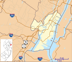
|pushpin_map_caption = Bergen Point in Hudson County in New Jersey |
|pushpin_map_caption = Bergen Point in Hudson County in New Jersey |
||
|subdivision_type = [[List of |
|subdivision_type = [[List of sovereign states|Country]] |
||
|subdivision_name = United States |
|subdivision_name = [[United States]] |
||
|subdivision_type1 = [[U.S. state|State]] |
|subdivision_type1 = [[U.S. state|State]] |
||
|subdivision_name1 = |
|subdivision_name1 = {{Flag|New Jersey}} |
||
|subdivision_type2 = [[List of counties in New Jersey|County]] |
|subdivision_type2 = [[List of counties in New Jersey|County]] |
||
|subdivision_name2 = [[Hudson County, New Jersey|Hudson]] |
|subdivision_name2 = [[Hudson County, New Jersey|Hudson]] |
||
| Line 29: | Line 32: | ||
|elevation_m = |
|elevation_m = |
||
|elevation_ft = 7 |
|elevation_ft = 7 |
||
| |
|coordinates = {{coord|40|38|51|N|74|08|29|W|region:US-NJ_type:city|display=inline,title}} |
||
|coordinates_type = region:US-NJ_type:city |
|||
|latd = 40 |
|||
|latm = 38 |
|||
|lats = 51 |
|||
|latNS = N |
|||
|longd = 74 |
|||
|longm = 08 |
|||
|longs = 29 |
|||
|longEW = W |
|||
|postal_code_type = |
|postal_code_type = |
||
|postal_code = |
|postal_code = |
||
| Line 48: | Line 42: | ||
|unit_pref = imperial |
|unit_pref = imperial |
||
}} |
}} |
||
'''Bergen Point''' is a [[Peninsula|point of land]] that lends its name to the adjacent [[Local government in New Jersey#Unincorporated communities|neighborhood]] in [[Bayonne, New Jersey|Bayonne]] in [[Hudson County, New Jersey|Hudson County]], [[ |
'''Bergen Point''' is a [[Peninsula|point of land]] that lends its name to the adjacent [[Local government in New Jersey#Unincorporated communities|neighborhood]] in [[Bayonne, New Jersey|Bayonne]] in [[Hudson County, New Jersey|Hudson County]], in the [[U.S. state]] of [[New Jersey]].<ref>[http://www.state.nj.us/infobank/localnames.txt Locality Search] {{webarchive|url=https://web.archive.org/web/20160709092825/http://www.state.nj.us/infobank/localnames.txt |date=July 9, 2016 }}, State of New Jersey. Accessed February 7, 2015.</ref> The point is located on the north side of [[Kill van Kull]] at [[Newark Bay]]. It is the section of the city closest to the [[Bayonne Bridge]].<ref>{{Cite book | publisher = Hagstrom Map Company, Inc | isbn = 978-0-88097-763-0 | title = Hudson County New Jersey Street Map | year = 2008 }}</ref> Historically the term has been used more broadly as synonymous with [[Constable Hook]], from which it is geographically separated at [[Port Johnston Coal Docks|Port Johnson]]. |
||
== History == |
|||
The area was connected to Staten Island with a ferry as early as the late 17th century, and was later developed as a resort.<ref>[http://www.bayonnelibrary.org/.../page_33-38_BergenPointByHenryR.pdf Bergen Point]</ref> In the late 18th century it |
The area was connected to [[Staten Island]] with a ferry as early as the late 17th century, and was later developed as a resort.<ref>[http://www.bayonnelibrary.org/.../page_33-38_BergenPointByHenryR.pdf Bergen Point]{{dead link|date=October 2016 |bot=InternetArchiveBot |fix-attempted=yes }}</ref><ref>{{Cite web|url=http://www.hagley.org/librarynews/hotel-latourette-most-fashionable-resort-suburban-district-new-york|title=Hotel Latourette: The Most Fashionable Resort in the Suburban District of New York|website=Hagley|date=February 6, 2013|access-date=November 3, 2016}}</ref> In the late 18th century it became more prominent as a ferry landing for travelers between [[New York City]] and [[Philadelphia]].<ref>[http://www.getnj.com/jchist/47a.shtml Paulus Hook Ferry]</ref> An 1837 US government coastal survey map identifies it as Vanhorn Point,<ref>NOAA Coastal Survey file T18.jpg, available at [https://nosimagery.noaa.gov/images/shoreline_surveys/survey_scans/NOAA_Shoreline_Survey_Scans.html] and attached to Wikipedia article on [[Curries Woods]].</ref> reflecting the name of a Dutch family that occupied the area just to the north called Pamrapo (among many other spellings, roughly today's [[Curries Woods]] neighborhood in [[Greenville, Jersey City|Greenville]]) from the mid-17th century. The Bergen Point Lighthouse, built offshore in 1849, was demolished and replaced with a skeletal tower in the mid 20th century.<ref>[http://www.njlhs.org/njlight/bergenpoint.html Bergen Point Lighthouse], 1849-1949, New Jersey Lighthouse Society.</ref> A charter was granted for the construction of The [[Jersey City and Bergen Point Plank Road]] in 1851.<ref>[https://books.google.com/books?id=3bf_dYwJ11MC Laws of the State of New Jersey], 1811, pp. 337–340</ref> |
||
[[Governor of New Jersey]] [[Jon Corzine]] announced on May 6, 2006, that funding was in place to extend the [[Hudson-Bergen Light Rail]] system to [[8th Street (HBLR station)|Eighth Street]]. Work was completed and the station opened in January 2011.<ref>Frassinelli, Mike. [http://www.nj.com/news/index.ssf/2011/01/nj_transit_opens_bayonne_8th_s.html "NJ Transit opens Bayonne 8th Street Station, extending Hudson-Bergen Light Rail service"], ''[[The Star-Ledger]]'', January 31, 2011. Accessed August 25, 2013.</ref> |
[[Governor of New Jersey]] [[Jon Corzine]] announced on May 6, 2006, that funding was in place to extend the [[Hudson-Bergen Light Rail]] system to [[8th Street (HBLR station)|Eighth Street]]. Work was completed and the station opened in January 2011.<ref>Frassinelli, Mike. [http://www.nj.com/news/index.ssf/2011/01/nj_transit_opens_bayonne_8th_s.html "NJ Transit opens Bayonne 8th Street Station, extending Hudson-Bergen Light Rail service"], ''[[The Star-Ledger]]'', January 31, 2011. Accessed August 25, 2013.</ref> |
||
A large portion of the point was once site of a [[Texaco]] plant, which was cleared and is slated to become a residential and recreational area along Newark Bay and Kill Van Kull.<ref>[http://www.nj.com/hudson/index.ssf/2015/09/bayonne_development_slated_to_bring_over_1200_hous.html#incart_river 1,200 housing units, recreation facilities planned for former Texaco site in Bayonne] Jersey Journal, Sept 2015</ref> Other former industrial sites are slated for mixed-use development.<ref>{{Cite web|url=https://hudsonreporter.com/2020/11/26/eyesores-no-more/|title = Eyesores no more?|date = November 26, 2020}}</ref><ref>{{Cite web|url=https://hudsonreporter.com/2021/09/15/public-hearing-for-bayview-development-slated-for-october/|title=Public hearing for Bayview development slated for October|date=September 15, 2021}}</ref> In 2022, the construction of a major studio at was announced. Called [[1888 Studios]], it will be the largest in New Jersey.<ref>{{Cite web|url=https://hudsonreporter.com/2022/03/31/bayonne-planning-board-approves-1888-studios-at-former-texaco-site/|title=Bayonne Planning Board approves 1888 Studios at former Texaco site|date=March 31, 2022}}</ref><ref>{{Cite web|url=https://jerseydigs.com/renderings-revealed-1888-studios-bayonne/|title = Renderings Revealed for NJ's Largest Film Production Complex in Bayonne|date = March 25, 2022}}</ref> |
|||
The renovated [[Collins Park (Bayonne, New Jersey)|Collins Park]] and walkways along the new developments are part of the [[Hackensack RiverWalk]]. |
|||
==Gallery== |
==Gallery== |
||
| Line 73: | Line 72: | ||
*[http://tidesandcurrents.noaa.gov/ports/ports.shtml?stn=8519483+Bergen%20Point%20West%20Reach&port=ny Bergen Point West Reach] data station ID 8519483 Physical Oceanographic Real-Time System, [[NOAA]]. |
*[http://tidesandcurrents.noaa.gov/ports/ports.shtml?stn=8519483+Bergen%20Point%20West%20Reach&port=ny Bergen Point West Reach] data station ID 8519483 Physical Oceanographic Real-Time System, [[NOAA]]. |
||
*[http://www.graveinfo.com/NJ/Bayonne/constablehook/index.html Bayonne Constable Hook Cemetery]. |
*[http://www.graveinfo.com/NJ/Bayonne/constablehook/index.html Bayonne Constable Hook Cemetery]. |
||
{{Bayonne, New Jersey}} |
|||
{{Hudson County, New Jersey}} |
{{Hudson County, New Jersey}} |
||
| Line 80: | Line 79: | ||
[[Category:Peninsulas of New Jersey]] |
[[Category:Peninsulas of New Jersey]] |
||
[[Category:Landforms of Hudson County, New Jersey]] |
[[Category:Landforms of Hudson County, New Jersey]] |
||
{{NewJersey-geo-stub}} |
|||
Latest revision as of 00:13, 24 July 2023
Bergen Point | |
|---|---|
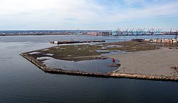
 Southwestern tip of Bergen Point | |
| Coordinates: 40°38′51″N 74°08′29″W / 40.64750°N 74.14139°W | |
| Country | United States |
| State | |
| County | Hudson |
| City | Bayonne |
| Elevation | 7 ft (2 m) |
| Area code | 201 |
| GNIS feature ID | 874681[1] |
Bergen Point is a point of land that lends its name to the adjacent neighborhood in Bayonne in Hudson County, in the U.S. state of New Jersey.[2] The point is located on the north side of Kill van Kull at Newark Bay. It is the section of the city closest to the Bayonne Bridge.[3] Historically the term has been used more broadly as synonymous with Constable Hook, from which it is geographically separated at Port Johnson.
History
[edit]The area was connected to Staten Island with a ferry as early as the late 17th century, and was later developed as a resort.[4][5] In the late 18th century it became more prominent as a ferry landing for travelers between New York City and Philadelphia.[6] An 1837 US government coastal survey map identifies it as Vanhorn Point,[7] reflecting the name of a Dutch family that occupied the area just to the north called Pamrapo (among many other spellings, roughly today's Curries Woods neighborhood in Greenville) from the mid-17th century. The Bergen Point Lighthouse, built offshore in 1849, was demolished and replaced with a skeletal tower in the mid 20th century.[8] A charter was granted for the construction of The Jersey City and Bergen Point Plank Road in 1851.[9]
Governor of New Jersey Jon Corzine announced on May 6, 2006, that funding was in place to extend the Hudson-Bergen Light Rail system to Eighth Street. Work was completed and the station opened in January 2011.[10]
A large portion of the point was once site of a Texaco plant, which was cleared and is slated to become a residential and recreational area along Newark Bay and Kill Van Kull.[11] Other former industrial sites are slated for mixed-use development.[12][13] In 2022, the construction of a major studio at was announced. Called 1888 Studios, it will be the largest in New Jersey.[14][15]
The renovated Collins Park and walkways along the new developments are part of the Hackensack RiverWalk.
Gallery
[edit]-
The Latourette House in Bergen Point was the birthplace of Samuel Francis Du Pont[16]
-
Bergen Point, 1974
-
The point lends its name to the neighborhood
See also
[edit]- Bergen Neck
- Hackensack RiverWalk
- Geography of New York–New Jersey Harbor Estuary
- Port of New York and New Jersey
References
[edit]- ^ a b "Bergen Point". Geographic Names Information System. United States Geological Survey, United States Department of the Interior.
- ^ Locality Search Archived July 9, 2016, at the Wayback Machine, State of New Jersey. Accessed February 7, 2015.
- ^ Hudson County New Jersey Street Map. Hagstrom Map Company, Inc. 2008. ISBN 978-0-88097-763-0.
- ^ Bergen Point[permanent dead link]
- ^ "Hotel Latourette: The Most Fashionable Resort in the Suburban District of New York". Hagley. February 6, 2013. Retrieved November 3, 2016.
- ^ Paulus Hook Ferry
- ^ NOAA Coastal Survey file T18.jpg, available at [1] and attached to Wikipedia article on Curries Woods.
- ^ Bergen Point Lighthouse, 1849-1949, New Jersey Lighthouse Society.
- ^ Laws of the State of New Jersey, 1811, pp. 337–340
- ^ Frassinelli, Mike. "NJ Transit opens Bayonne 8th Street Station, extending Hudson-Bergen Light Rail service", The Star-Ledger, January 31, 2011. Accessed August 25, 2013.
- ^ 1,200 housing units, recreation facilities planned for former Texaco site in Bayonne Jersey Journal, Sept 2015
- ^ "Eyesores no more?". November 26, 2020.
- ^ "Public hearing for Bayview development slated for October". September 15, 2021.
- ^ "Bayonne Planning Board approves 1888 Studios at former Texaco site". March 31, 2022.
- ^ "Renderings Revealed for NJ's Largest Film Production Complex in Bayonne". March 25, 2022.
- ^ "Part of What the World Did not Know Until Now" (PDF). Bayonne Public Library. November 19, 1946.
External links
[edit]- Bergen Point West Reach data station ID 8519483 Physical Oceanographic Real-Time System, NOAA.
- Bayonne Constable Hook Cemetery.


![The Latourette House in Bergen Point was the birthplace of Samuel Francis Du Pont[16]](http://upload.wikimedia.org/wikipedia/commons/thumb/0/00/The_Latourette_House%2C_Bergen_Point%2C_New_Jersey.jpg/120px-The_Latourette_House%2C_Bergen_Point%2C_New_Jersey.jpg)


